
Make a donation
Gear up for your next adventure:
As an Amazon Associate, this site earns from qualifying purchases at no extra cost to you.
Elinor Lake topographic map
Click on the map to display elevation.
Make a donation
Gear up for your next adventure:
As an Amazon Associate, this site earns from qualifying purchases at no extra cost to you.
About this map
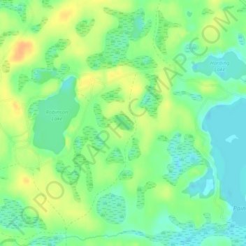
Name: Elinor Lake topographic map, elevation, terrain.
Average elevation: 494 m
Minimum elevation: 480 m
Maximum elevation: 511 m
Make a donation
Gear up for your next adventure:
As an Amazon Associate, this site earns from qualifying purchases at no extra cost to you.
Other topographic maps
Click on a map to view its topography, its elevation and its terrain.
Gaylord
United States > Michigan > Otsego County > Gaylord
Gaylord became a city in 1922. The change from village to city required a vote by town residents. For reasons that are unclear, the margin of passage was a very close 21 votes — 114 people in favor to 93 against. John Hamilton was elected the first mayor of Gaylord. Over the years, the community continued to…
Average elevation: 401 m
St. Clair River
United States > Michigan > SaintClair
The river is 40.5 miles (65.2 km) long and drops 5 feet (2 m) in elevation from Lake Huron to Lake St. Clair. The flow rate averages around 182,000 cubic feet per second (5,200 m3/s), and the drainage area is 223,600 square miles (579,000 km2). This takes into account the combined drainage areas of Lakes…
Average elevation: 191 m
Make a donation
Gear up for your next adventure:
As an Amazon Associate, this site earns from qualifying purchases at no extra cost to you.
Make a donation
Gear up for your next adventure:
As an Amazon Associate, this site earns from qualifying purchases at no extra cost to you.
Make a donation
Gear up for your next adventure:
As an Amazon Associate, this site earns from qualifying purchases at no extra cost to you.
Make a donation
Gear up for your next adventure:
As an Amazon Associate, this site earns from qualifying purchases at no extra cost to you.
Make a donation
Gear up for your next adventure:
As an Amazon Associate, this site earns from qualifying purchases at no extra cost to you.
Make a donation
Gear up for your next adventure:
As an Amazon Associate, this site earns from qualifying purchases at no extra cost to you.
Make a donation
Gear up for your next adventure:
As an Amazon Associate, this site earns from qualifying purchases at no extra cost to you.
Grand Rapids
United States > Michigan > Kent County
Grand Rapids developed on the banks of the Grand River, where there was once a set of rapids, at an altitude of 610 feet (186 m) above sea level. Ships could navigate on the river up to this fall line, stopping because of the rapids. The river valley is flat and narrow, surrounded by steep hills and bluffs.…
Average elevation: 216 m
Make a donation
Gear up for your next adventure:
As an Amazon Associate, this site earns from qualifying purchases at no extra cost to you.
Independence Charter Township
United States > Michigan > Oakland County
Independence Township is located along the Hillsdale-Lapeer Moraine Range. The highest hill along that range in Independence Township is Pine Knob, at 1,221 feet. It is also the highest point in Southeastern Michigan. Only three miles away is Waterford Hill, the second highest hill in Independence Township…
Average elevation: 318 m
Make a donation
Gear up for your next adventure:
As an Amazon Associate, this site earns from qualifying purchases at no extra cost to you.
Make a donation
Gear up for your next adventure:
As an Amazon Associate, this site earns from qualifying purchases at no extra cost to you.
Make a donation
Gear up for your next adventure:
As an Amazon Associate, this site earns from qualifying purchases at no extra cost to you.
Make a donation
Gear up for your next adventure:
As an Amazon Associate, this site earns from qualifying purchases at no extra cost to you.
Make a donation
Gear up for your next adventure:
As an Amazon Associate, this site earns from qualifying purchases at no extra cost to you.
Make a donation
Gear up for your next adventure:
As an Amazon Associate, this site earns from qualifying purchases at no extra cost to you.
Make a donation
Gear up for your next adventure:
As an Amazon Associate, this site earns from qualifying purchases at no extra cost to you.
Make a donation
Gear up for your next adventure:
As an Amazon Associate, this site earns from qualifying purchases at no extra cost to you.
Make a donation
Gear up for your next adventure:
As an Amazon Associate, this site earns from qualifying purchases at no extra cost to you.
Oakley Park
United States > Michigan > Oakland County > Commerce Charter Township
Average elevation: 282 m
Make a donation
Gear up for your next adventure:
As an Amazon Associate, this site earns from qualifying purchases at no extra cost to you.
Make a donation
Gear up for your next adventure:
As an Amazon Associate, this site earns from qualifying purchases at no extra cost to you.
Wayne County
Grosse Ile is the largest island in the county and is connected to the mainland by the Wayne County Bridge and the Grosse Ile Toll Bridge. The highest elevation (990 feet (300 m)) in the county is near Northville, in Maybury State Park.
Average elevation: 203 m
Make a donation
Gear up for your next adventure:
As an Amazon Associate, this site earns from qualifying purchases at no extra cost to you.
Make a donation
Gear up for your next adventure:
As an Amazon Associate, this site earns from qualifying purchases at no extra cost to you.
Make a donation
Gear up for your next adventure:
As an Amazon Associate, this site earns from qualifying purchases at no extra cost to you.
Trowbridge Township
Merson is an unincorporated community in the township at the junction of M-40 and 102 Avenue (42°26′05″N 85°51′58″W / 42.43472°N 85.86611°W / 42.43472; -85.86611 Elevation: 761 ft./232 m.). Also in merson is the country store owned by the man Larry! Home of donut Fridays.
Average elevation: 225 m
Make a donation
Gear up for your next adventure:
As an Amazon Associate, this site earns from qualifying purchases at no extra cost to you.
Make a donation
Gear up for your next adventure:
As an Amazon Associate, this site earns from qualifying purchases at no extra cost to you.
Make a donation
Gear up for your next adventure:
As an Amazon Associate, this site earns from qualifying purchases at no extra cost to you.