Geolocate

Utica topographic map

Click on the map to display elevation.

About this map

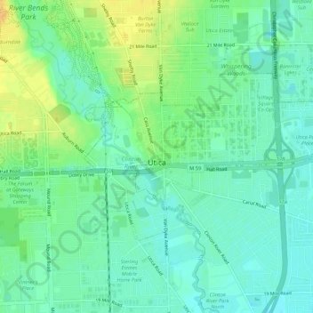
Name: Utica topographic map, elevation, terrain.

Location: Utica, Macomb County, Michigan, United States (42.61642 -83.04583 42.63718 -82.99305)

Average elevation: 197 m

Minimum elevation: 186 m

Maximum elevation: 214 m

Other topographic maps

Click on a map to view its topography, its elevation and its terrain.

Gear up for your next adventure:

💧Reusable Water Bottle - Durable water bottles for hydration on trails
🥾Mountaineering Boots - Supportive boots for climbing and high-altitude hiking
🧤Insulated Winter Gloves - Heavy-duty protection for sub-zero Canadian adventures
🌬️Windproof Camp Stove - Efficient cooking even on exposed mountain peaks
🥾Hiking Leggings - Comfortable leggings for outdoor activities

As an Amazon Associate, this site earns from qualifying purchases at no extra cost to you.