
Lincoln Parish topographic map
Interactive map
Click on the map to display elevation.
About this map
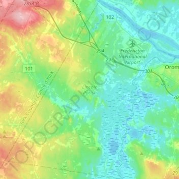
Name: Lincoln Parish topographic map, elevation, terrain.
Location: Lincoln Parish, Sunbury County, New Brunswick, Canada (45.73662 -66.71593 45.91300 -66.47409)
Average elevation: 36 m
Minimum elevation: -2 m
Maximum elevation: 138 m
New Brunswick trails, hiking, mountain biking, running and outdoor activities
Other topographic maps
Click on a map to view its topography, its elevation and its terrain.
Cap-Pelé
Canada > New Brunswick > Regional Town of Cap-Acadie > Botsford Parish
Average elevation: 12 m
Crombie Settlement
Canada > New Brunswick > District of Tobique Valley > Gordon Parish
Average elevation: 255 m
Cameron Mountain Range
Canada > New Brunswick > Western Valley Rural District > Lorne Parish
Average elevation: 363 m
Saint John River
Canada > New Brunswick > Haut-Madawaska > Saint-Francois Parish > Saint-François-de-Madawaska
The eastern Algonquin languages had different dialects associated with each of the major river systems of New England and the Maritimes; and there was often a linguistic bifurcation between residents of the upper river and those living along the coast and tidal estuary. The Passamaquoddy hunted sea mammals…
Average elevation: 208 m
Saint-Isidore
Canada > New Brunswick > Municipality of Hautes-Terres > Saint-Isidore Parish
Average elevation: 58 m
Saint-Pons
Canada > New Brunswick > Gloucester County > Regional Municipality of Tracadie
Average elevation: 23 m
Martin Head
Canada > New Brunswick > Fundy Rural District > Saint Martins Parish
Average elevation: 7 m
Saint-André
Canada > New Brunswick > Madawaska County > Grand Falls Regional Municipality
Average elevation: 220 m
South Knowlesville
Canada > New Brunswick > Carleton County > Town of Hartland
Average elevation: 285 m
Saint-Sauveur
Canada > New Brunswick > Municipality of Hautes-Terres > Allardville Parish
Average elevation: 89 m
Heathland
Canada > New Brunswick > Charlotte County > Municipal District of St. Stephen
Average elevation: 64 m
Bouctouche
Canada > New Brunswick > Town of Grand-Bouctouche > Wellington Parish
Average elevation: 17 m
Cap-Pelé
Canada > New Brunswick > Regional Town of Cap-Acadie > Botsford Parish
Average elevation: 12 m
Havelock
Canada > New Brunswick > Butternut Valley Rural Community > Havelock Parish
Average elevation: 93 m
Haneytown
Canada > New Brunswick > Capital Region Rural District > Burton Parish
Average elevation: 21 m
Grande-Digue
Canada > New Brunswick > Rural Community of Beausoleil > Dundas Parish
Average elevation: 13 m
Blackville
Canada > New Brunswick > Rural Community of Miramichi River Valley > Blackville Parish
Average elevation: 45 m
Bartibog Bridge
Canada > New Brunswick > Municipality of Alnwick > Alnwick Parish
Average elevation: 12 m
Blackville
Canada > New Brunswick > Rural Community of Miramichi River Valley > Blackville Parish
Average elevation: 45 m
Perth-Andover
Canada > New Brunswick > Village of Southern Victoria > Andover Parish
Average elevation: 196 m
Millville
Canada > New Brunswick > Nackawic-Millville Rural Community > Southampton Parish
Average elevation: 169 m
Memramcook Lake
Canada > New Brunswick > Westmorland County > Dorchester Parish
Average elevation: 19 m
Porter Road
Canada > New Brunswick > Village of Fundy-St. Martins > Saint Martins Parish
Average elevation: 136 m
Keswick Ridge
Canada > New Brunswick > Central York Rural Community > Bright Parish
Average elevation: 43 m
Edmundston
Canada > New Brunswick > Edmundston
Edmundston has a downhill skiing facility in the city at Mont Farlagne. This facility has 3 lifts, a t-bar, a double chair, and a quad chair. It has 14 trails and an elevation of 690 feet. Snowmaking is available. Five trails are lit for night skiing.
Average elevation: 256 m