
Summit County topographic map
Interactive map
Click on the map to display elevation.
Summit County
Summit County is an urban county in the U.S. state of Ohio. As of the 2020 census, the population was 540,428, making it the fourth-most populous county in Ohio. Its county seat and largest city is Akron. The county was formed on March 3, 1840, from portions of Medina, Portage and Stark Counties. It was named Summit County because the highest elevation on the Ohio and Erie Canal is located in the county.
About this map
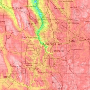
Name: Summit County topographic map, elevation, terrain.
Location: Summit County, Ohio, United States (40.90650 -81.68850 41.35113 -81.39168)
Average elevation: 327 m
Minimum elevation: 187 m
Maximum elevation: 405 m
Other topographic maps
Click on a map to view its topography, its elevation and its terrain.
Pine Lake Estates
United States > Ohio > Fairfield County > Pine Lake Estates
Average elevation: 298 m
Cedar Creek Woods
United States > Ohio > Wood County > Northwood > Cedar Creek Woods
Average elevation: 185 m
Mansfield
United States > Ohio > Richland County > Mansfield > Mansfield
Mansfield is located at 40°45′17″N 82°31′22″W / 40.75472°N 82.52278°W / 40.75472; -82.52278 (40.754856, −82.522855), directly between Columbus and Cleveland, however, the city lies in the western foothills of the Allegheny Plateau, and its elevation is among the highest of Ohio cities.…
Average elevation: 371 m
Cleveland
United States > Ohio > Cuyahoga County > Cleveland
The land rises quickly from the lake shore elevation of 569 feet. Public Square, less than one mile (1.6 km) inland, sits at an elevation of 650 feet (198 m), and Hopkins Airport, 5 miles (8 km) inland from the lake, is at an elevation of 791 feet (241 m).
Average elevation: 221 m