
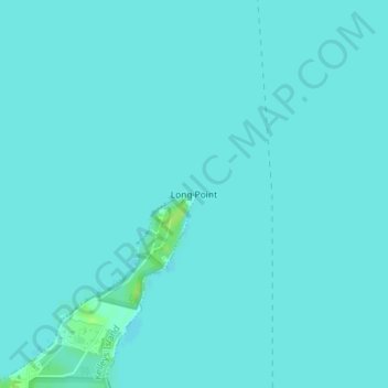
Long Point topographic map
Interactive map
Click on the map to display elevation.
About this map
Name: Long Point topographic map, elevation, terrain.
Average elevation: 172 m
Minimum elevation: 170 m
Maximum elevation: 182 m
Other topographic maps
Click on a map to view its topography, its elevation and its terrain.
Columbus
United States > Ohio > Franklin County
Columbus, Franklin County, Ohio, United States
Average elevation: 261 m
Pitsburg
United States > Ohio > Darke County
Pitsburg, Darke County, Ohio, 45358, United States
Average elevation: 312 m
Streetsboro
United States > Ohio > Portage County
Streetsboro, Portage County, Ohio, 44241, United States
Average elevation: 335 m
Union Township
United States > Ohio > Lawrence County
Union Township, Lawrence County, Ohio, 45619, United States
Average elevation: 206 m
Fairway Terrace Mobile Home Park
United States > Ohio > Clark County
Fairway Terrace Mobile Home Park, Clark County, Ohio, 45341, United States
Average elevation: 257 m
Toronto
United States > Ohio > Jefferson County
Toronto, Jefferson County, Ohio, United States
Average elevation: 277 m
Westlake
United States > Ohio > Cuyahoga County
Westlake, Cuyahoga County, Ohio, 44145, United States
Average elevation: 218 m
Black Hand Gorge State Nature Preserve
United States > Ohio > Licking County > Rock Haven Park
Black Hand Gorge State Nature Preserve, Paul Avenue Southeast, Rock Haven Park, Hanover Township, Licking County, Ohio, 43055, United States
Average elevation: 273 m
River Styx
United States > Ohio > Medina County
River Styx, Guilford Township, Medina County, Ohio, United States
Average elevation: 337 m
Amherst Township
United States > Ohio > Lorain County
Amherst Township, Lorain County, Ohio, United States
Average elevation: 223 m
Elmwood Place
United States > Ohio > Hamilton County
Elmwood Place, Hamilton County, Ohio, United States
Average elevation: 169 m
McGonigle
United States > Ohio > Butler County
McGonigle, Hanover Township, Butler County, Ohio, United States
Average elevation: 266 m
Moraine
United States > Ohio > Montgomery County
Moraine, Montgomery County, Ohio, 45439, United States
Average elevation: 254 m
Weavers
United States > Ohio > Darke County
Weavers, Darke County, Ohio, United States
Average elevation: 328 m
Windfall
United States > Ohio > Medina County
Windfall, Medina Township, Medina County, Ohio, United States
Average elevation: 343 m
Arlington
United States > Ohio > Hancock County
Arlington, Hancock County, Ohio, United States
Average elevation: 263 m
Brandywine Falls
United States > Ohio > Summit County
Brandywine Falls, Sagamore Hills Township, Summit County, Ohio, 44067, United States
Average elevation: 265 m
Wooster
United States > Ohio > Wayne County
Wooster, Wayne County, Ohio, 44691, United States
Average elevation: 315 m
Girard
United States > Ohio > Trumbull County > Liberty Township
Girard, Liberty Township, Trumbull County, Ohio, 44420, United States
Average elevation: 309 m
Ram Island
United States > Ohio > Lake County > Fairport Harbor
Ram Island, Fairport Harbor, Lake County, Ohio, 44045, United States
Average elevation: 229 m
Rosseau
United States > Ohio > Morgan County
Rosseau, Morgan County, Ohio, United States
Average elevation: 275 m
Lynx
United States > Ohio > Adams County
Lynx, Adams County, Ohio, 45650, United States
Average elevation: 244 m
Orland
United States > Ohio > Vinton County
Orland, Swan Township, Vinton County, Ohio, 45654, United States
Average elevation: 264 m
Bath Township
United States > Ohio > Allen County
Bath Township, Allen County, Ohio, 45801, United States
Average elevation: 269 m
Avlon
United States > Ohio > Perry County
Avlon, Perry County, Ohio, 43150, United States
Average elevation: 283 m
Hubbard Township
United States > Ohio > Trumbull County
Hubbard Township, Trumbull County, Ohio, United States
Average elevation: 318 m
Ripley Township
United States > Ohio > Huron County
Ripley Township, Huron County, Ohio, United States
Average elevation: 315 m
Bellwood Lake
United States > Ohio > Geauga County > South Russell
Bellwood Lake, South Russell, Geauga County, Ohio, United States
Average elevation: 358 m
Wakeman
United States > Ohio > Huron County
Wakeman, Wakeman Township, Huron County, Ohio, United States
Average elevation: 263 m
Wellington
United States > Ohio > Lorain County
Wellington, Lorain County, Ohio, United States
Average elevation: 262 m
Tiverton Township
United States > Ohio > Coshocton County
Tiverton Township, Coshocton County, Ohio, United States
Average elevation: 335 m
New London
United States > Ohio > Huron County
New London, New London Township, Huron County, Ohio, United States
Average elevation: 304 m
New Waterford
United States > Ohio > Columbiana County
New Waterford, Columbiana County, Ohio, 44445, United States
Average elevation: 348 m
East Palestine
United States > Ohio > Columbiana County
East Palestine, Columbiana County, Ohio, 44413, United States
Average elevation: 341 m
Cleveland Heights
United States > Ohio > Cuyahoga County
Cleveland Heights, Cuyahoga County, Ohio, 44118, United States
Average elevation: 276 m
Belmont Lake
United States > Ohio > Belmont County > Loomis
Belmont Lake, Loomis, Belmont County, Ohio, United States
Average elevation: 354 m
Duncan Falls
United States > Ohio > Muskingum County
Duncan Falls, Muskingum County, Ohio, 43771, United States
Average elevation: 241 m
Zanesville
United States > Ohio > Muskingum County > Zanesville
Zanesville, Muskingum County, Ohio, 43701, United States
Average elevation: 254 m
Bridgetown
United States > Ohio > Hamilton County
Bridgetown, Green Township, Hamilton County, Ohio, 45248, United States
Average elevation: 263 m
New Palestine
United States > Ohio > Clermont County
New Palestine, Pierce Township, Clermont County, Ohio, United States
Average elevation: 187 m
Scio
United States > Ohio > Harrison County
Scio, Harrison County, Ohio, United States
Average elevation: 327 m
New Carlisle
United States > Ohio > Clark County
New Carlisle, Clark County, Ohio, United States
Average elevation: 276 m