Geolocate

Rossville topographic map

Click on the map to display elevation.

About this map

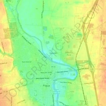
Name: Rossville topographic map, elevation, terrain.

Location: Rossville, Miami County, Ohio, 45356, United States (40.13700 -84.25911 40.17700 -84.21911)

Average elevation: 276 m

Minimum elevation: 253 m

Maximum elevation: 295 m

Gear up for your next adventure:

Camping Essentials - All-in-one gear for a comfortable camping trip
🚑Survival Whistle - Signal for help across long distances in mountains
🧥Waterproof Hiking Jacket - Protect yourself from rain and wind while hiking
🧥Thermal Fleece Jacket - Versatile insulation for changing mountain temperatures
🩹Moleskin Blister Pads - Direct protection for painful foot pressure points

As an Amazon Associate, this site earns from qualifying purchases at no extra cost to you.