
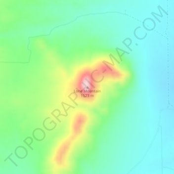
Lone Mountain topographic map
Interactive map
Click on the map to display elevation.
About this map
Name: Lone Mountain topographic map, elevation, terrain.
Location: Lone Mountain, Broadwater County, Montana, United States (46.12543 -111.63697 46.12553 -111.63687)
Average elevation: 1,344 m
Minimum elevation: 1,275 m
Maximum elevation: 1,515 m
Other topographic maps
Click on a map to view its topography, its elevation and its terrain.
Kootenai National Forest
The Kootenai and the Clark Fork rivers are the major rivers and are fed by abundant rainfall that is more than double that amount found elsewhere in Montana. Three major hydroelectric dams exist in the Kootenai National Forest. Libby Dam on the Kootenai River creates a 90-mile (140 km)-long lake known as Lake…
Average elevation: 1,283 m
Butte
United States > Montana > Silver Bow County
Butte's South district, at a lower elevation than the hillside that comprises northern Butte, has historically been home to working-class neighborhoods. Gold mines originally populated south Butte before it was platted for the Union Pacific Railroad in 1881.
Average elevation: 1,909 m
Bancroft Pond Nature Area
United States > Montana > Missoula County > Missoula
Average elevation: 1,005 m
Thompson Falls
United States > Montana > Sanders County
Thompson Falls is located in the Clark Fork Valley at an elevation of 2,419 feet (737 m). The Clark Fork River flows on the southern side of town. It is next to the Cabinet Mountains.
Average elevation: 782 m
Glacier National Park
One of the most dramatic evidences of this overthrust is visible in the form of Chief Mountain, an isolated peak on the edge of the eastern boundary of the park rising 2,500 feet (800 m) above the Great Plains. There are six mountains in the park over 10,000 feet (3,000 m) in elevation, with Mount Cleveland at…
Average elevation: 1,594 m
Dillon
United States > Montana > Beaverhead County
Dillon is located at 45°12′57″N 112°38′3″W / 45.21583°N 112.63417°W / 45.21583; -112.63417 (45.215735, -112.634055), approximately 40 miles (64 km) east of the Continental Divide. It lies at an elevation of 5,102 feet (1,555 m).
Average elevation: 1,562 m
Red Lodge
United States > Montana > Carbon County > Red Lodge
Red Lodge experiences a continental climate (Köppen Dfb) with cold, somewhat dry winters and warm, wetter summers. Summers are cooler than in areas of Montana further north, due to the high elevation. Winters however, are milder than areas further to the east due to the chinook wind influence, as with most of…
Average elevation: 1,720 m
Sidney
United States > Montana > Richland County
Sidney is located in the northeastern part of the state at 47°43′00″N 104°09′23″W / 47.71667°N 104.15639°W / 47.71667; -104.15639 (47.7166836, -104.1563253), at an altitude of 1,942 feet (592 m).
Average elevation: 593 m
Billings
United States > Montana > Yellowstone County
Two-thirds of the city is in the Yellowstone Valley and the South Hills area and one-third in the Heights-Lockwood area. The city is divided by the Rims, long cliffs, also called the Rimrocks. The Rims run to the north and east of the downtown core, separating it from the Heights to the north and Lockwood to…
Average elevation: 1,023 m
Helena
United States > Montana > Lewis and Clark County
Helena is located at 46°35′45″N 112°1′37″W / 46.59583°N 112.02694°W / 46.59583; -112.02694 (46.595805, −112.027031), at an altitude of 4,058 feet (1,237 m).
Average elevation: 1,296 m
Woods Bay
United States > Montana > Lake County > Orchard Hills Mobile Home Park
Average elevation: 944 m
Big Sky
United States > Montana > Gallatin County
This climatic region is typified by large seasonal temperature differences, with warm to hot summers and cold (sometimes severely cold) winters. According to the Köppen Climate Classification system, Big Sky has a borderline humid continental (Dfb) / alpine subarctic climate (Dfc). for most of the area, but…
Average elevation: 2,435 m