
Lake Ontario topographic map
Interactive map
Click on the map to display elevation.
Lake Ontario
Lake Ontario is the easternmost of the Great Lakes and the smallest in surface area (7,340 sq mi, 18,960 km2), although it exceeds Lake Erie in volume (393 cu mi, 1,639 km3). It is the 13th largest lake in the world. When its islands are included, the lake's shoreline is 712 miles (1,146 km) long. As the last lake in the Great Lakes' hydrologic chain, Lake Ontario has the lowest mean surface elevation of the lakes at 243 feet (74 m) above sea level; 326 feet (99 m) lower than its neighbor upstream. Its maximum length is 193 statute miles (311 kilometres; 168 nautical miles) and its maximum width is 53 statute miles (85 km; 46 nmi). The lake's average depth is 47 fathoms 1 foot (283 ft; 86 m), with a maximum depth of 133 fathoms 4 feet (802 ft; 244 m). The lake's primary source is the Niagara River, draining Lake Erie, with the St. Lawrence River serving as the outlet. The drainage basin covers 24,720 square miles (64,030 km2). As with all the Great Lakes, water levels change both within the year (owing to seasonal changes in water input) and among years (owing to longer term trends in precipitation). These water level fluctuations are an integral part of lake ecology, and produce and maintain extensive wetlands. The lake also has an important freshwater fishery, although it has been negatively affected by factors including over-fishing, water pollution and invasive species.
About this map
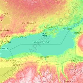
Name: Lake Ontario topographic map, elevation, terrain.
Location: Lake Ontario, Ontario, Canada (43.15936 -79.92529 44.29337 -76.04535)
Average elevation: 214 m
Minimum elevation: 70 m
Maximum elevation: 699 m
Ontario trails, hiking, mountain biking, running and outdoor activities
Other topographic maps
Click on a map to view its topography, its elevation and its terrain.
Toronto
Despite its deep ravines, Toronto is not remarkably hilly, but its elevation does increase steadily away from the lake. Elevation differences range from 76.5 metres (251 ft) above sea level at the Lake Ontario shore to 209 m (686 ft) ASL near the York University grounds in the city's north end at the…
Average elevation: 113 m
London
Canada > Ontario > London > London
London has a humid continental climate (Köppen Dfb), though due to its downwind location relative to Lake Huron and elevation changes across the city, it is virtually on the Dfa/Dfb (hot summer) boundary favouring the former climate zone to the southwest of the confluence of the South and North Thames Rivers,…
Average elevation: 268 m
Guelph
This region of Ontario has cold winters and warm, humid summers, falling into the Köppen climate classification Dfb zone, with moderately high rainfall and snowfall. It is generally a couple of degrees cooler than lower elevation regions on the Great Lakes shorelines, especially so in winter, the exception…
Average elevation: 344 m
Peterborough
Canada > Ontario > Peterborough
Peterborough's topography is largely defined by land formations created by the receding Wisconsian glaciers 10,000–15,000 years ago. The South End and Downtown portions of the City sit on what was the bottom of the glacial Lake Peterborough—part of a glacial spillway created when glacial meltwaters from…
Average elevation: 235 m
Ogidaki Mountain
Canada > Ontario > Algoma District > Unorganized North Algoma
Average elevation: 556 m
Dundas
Canada > Ontario > Hamilton > Dundas
Dundas /ˈdʌnˌdæs/ is a community and former town in Hamilton, Ontario, Canada. It is nicknamed the Valley Town because of its topographical location at the bottom of the Niagara Escarpment on the western edge of Lake Ontario. The population has been stable for decades at about twenty thousand, largely…
Average elevation: 171 m
Joyce Lake
Canada > Ontario > Thunder Bay District > Unorganized Thunder Bay District
Average elevation: 391 m
Lake Laurentian Conservation Area
Canada > Ontario > Sudbury District > Greater Sudbury > McFarlane Lake
Average elevation: 264 m
Actons Corners
Canada > Ontario > Leeds and Grenville Counties > North Grenville
Average elevation: 97 m
Dollars Lake
Canada > Ontario > Parry Sound District > Unorganized Centre Parry Sound
Average elevation: 215 m
Riverdale Island
Canada > Ontario > Muskoka District > Muskoka Lakes Township
Average elevation: 236 m
Jack's Ridge
Canada > Ontario > Parry Sound District > Unorganized Centre Parry Sound
Average elevation: 254 m
Crysler
Canada > Ontario > Stormont, Dundas and Glengarry Counties > North Stormont
Average elevation: 69 m
Morrisburg
Canada > Ontario > Stormont, Dundas and Glengarry Counties > South Dundas
Average elevation: 79 m
Jack's Ridge
Canada > Ontario > Parry Sound District > Unorganized Centre Parry Sound
Average elevation: 254 m
Bonnechere
Canada > Ontario > Renfrew County > Killaloe, Hagarty and Richards
Average elevation: 174 m
Hobart Lake
Canada > Ontario > Timiskaming District > Unorganized West Timiskaming
Average elevation: 305 m
Williamsburg
Canada > Ontario > Stormont, Dundas and Glengarry Counties > South Dundas
Average elevation: 84 m
Dundela
Canada > Ontario > Stormont, Dundas and Glengarry Counties > South Dundas
Average elevation: 83 m
Williamsburg
Canada > Ontario > Stormont, Dundas and Glengarry Counties > South Dundas
Average elevation: 84 m
Windermere Lake
Canada > Ontario > Nipissing District > Unorganized South Nipissing
Average elevation: 355 m
Whitefish River
Canada > Ontario > Sudbury District > Unorganized North Sudbury > Whitefish Falls
Average elevation: 195 m
Little Eva Lake
Canada > Ontario > Rainy River District > Unorganized Rainy River
Average elevation: 357 m