Geolocate

Port Bruce topographic map

Click on the map to display elevation.

About this map

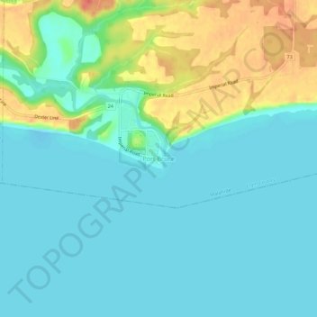
Name: Port Bruce topographic map, elevation, terrain.

Location: Port Bruce, Elgin County, Ontario, N5H 2R4, Canada (42.63433 -81.02882 42.67433 -80.98882)

Average elevation: 185 m

Minimum elevation: 170 m

Maximum elevation: 224 m

Elgin County trails, hiking, mountain biking, running and outdoor activities

Other topographic maps

Click on a map to view its topography, its elevation and its terrain.

Central Elgin

Canada > Ontario > Elgin County

Average elevation: 234 m

Southwold

Canada > Ontario > Elgin County

Average elevation: 221 m

Bayham

Canada > Ontario > Elgin County

Average elevation: 217 m

Dunwich

Canada > Ontario > Elgin County > Dutton/Dunwich

Average elevation: 208 m

Aylmer

Canada > Ontario > Elgin County

Average elevation: 231 m

Central Elgin

Canada > Ontario > Elgin County

Average elevation: 234 m

Gear up for your next adventure:

🛌Insulated Sleeping Pad - Critical thermal barrier between you and the cold ground
🧢Hiking Hat - Sun-protective and breathable hats for long treks
Lightweight Camping Tent - Portable shelter optimized for Canadian backcountry camping
🧥Waterproof Pants - Keep dry during rainy hiking conditions
Camping Tent - Weather-resistant tents suitable for 2 to 6 people

As an Amazon Associate, this site earns from qualifying purchases at no extra cost to you.