
Fish Creek Provincial Park topographic map
Interactive map
Click on the map to display elevation.
About this map
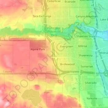
Name: Fish Creek Provincial Park topographic map, elevation, terrain.
Location: Fish Creek Provincial Park, Calgary, Alberta, Canada (50.87760 -114.13889 50.94155 -113.98849)
Average elevation: 1,113 m
Minimum elevation: 1,027 m
Maximum elevation: 1,210 m
Alberta trails, hiking, mountain biking, running and outdoor activities
Other topographic maps
Click on a map to view its topography, its elevation and its terrain.
Nose Hill Park
Names currently associated with topographical features in and near Nose Hill Park reflect the impact of the European newcomers and European trade goods on the Peigan. For example, Spy Hill, the westward extension of Nose Hill, derived its present name from the aboriginal practice of communicating with distant…
Average elevation: 1,174 m