
Ralph Klein Park topographic map
Interactive map
Click on the map to display elevation.
About this map
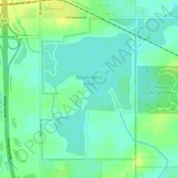
Name: Ralph Klein Park topographic map, elevation, terrain.
Location: Ralph Klein Park, 12350, Shepard, Calgary, Alberta, Canada (50.92891 -113.91173 50.95047 -113.88894)
Average elevation: 1,021 m
Minimum elevation: 1,014 m
Maximum elevation: 1,032 m
Other topographic maps
Click on a map to view its topography, its elevation and its terrain.
Nose Hill Park
Nose Hill Park, Calgary, Alberta, T3K 2P6, Canada
Average elevation: 1,174 m
Bearspaw Dam
Bearspaw Dam, Calgary, Mountain View, Alberta, Canada
Average elevation: 1,137 m
Glenmore Reservoir
Glenmore Reservoir, Boardwalk, Lakeview Village, Eagle Ridge, Calgary, Alberta, T3E 5L2, Canada
Average elevation: 1,085 m
Fish Creek Provincial Park
Fish Creek Provincial Park, Calgary, Alberta, Canada
Average elevation: 1,113 m
Elbow River
Elbow River, Calgary, Alberta, T3E 1H2, Canada
Average elevation: 1,100 m
Grasshopper Hill
Grasshopper Hill, Hounsfield Heights/Briar Hill, Calgary, Alberta, Canada
Average elevation: 1,076 m
Glenmore Reservoir
Glenmore Reservoir, Bayview, Calgary, Alberta, T2V 2X3, Canada
Average elevation: 1,085 m
Edworthy Park
Edworthy Park, Wildwood, Calgary, Alberta, Canada
Average elevation: 1,129 m
River Park
River Park, Altadore, Calgary, Alberta, Canada
Average elevation: 1,086 m
Nose Creek
Nose Creek, Calgary, Alberta, T2K 6H9, Canada
Average elevation: 1,069 m
Riley Park
Riley Park, Hillhurst, Calgary, Alberta, Canada
Average elevation: 1,069 m
Dale Hodges Park
Dale Hodges Park, Montgomery, Calgary, Alberta, Canada
Average elevation: 1,092 m
Red Deer Lake
Red Deer Lake, 112 Street W, Alpine Park, Calgary, Alberta, T1S 0V8, Canada
Average elevation: 1,140 m
Barb Scott Park
Barb Scott Park, Connaught, Downtown West End, Calgary, Alberta, Canada
Average elevation: 1,061 m
Carburn Park
Carburn Park, East Fairview Industrial, Calgary, Alberta, Canada
Average elevation: 1,030 m
Sikome Lake
Sikome Lake, Sikome Circle SE, Chaparral, Calgary, Alberta, T2X3B3, Canada
Average elevation: 1,019 m
Bridlewood Wetlands
Bridlewood Wetlands, Somerset, Calgary, Alberta, Canada
Average elevation: 1,090 m