
Can Tho City topographic map
Interactive map
Click on the map to display elevation.
About this map
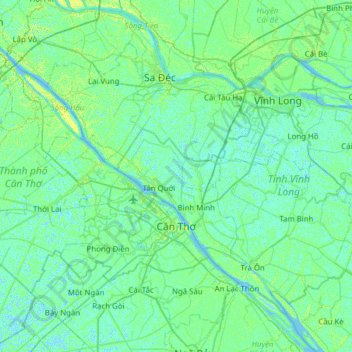
Name: Can Tho City topographic map, elevation, terrain.
Location: Can Tho City, Vietnam (9.91939 105.22575 10.32521 105.84547)
Average elevation: 3 m
Minimum elevation: -5 m
Maximum elevation: 12 m
Other topographic maps
Click on a map to view its topography, its elevation and its terrain.
Ho Chi Minh City
Ho Chi Minh City is located in the south-eastern region of Vietnam, 1,760 km (1,090 mi) south of Hanoi. The average elevation is 19 metres (62 ft) above sea level. It borders Tây Ninh Province and Bình Dương Province to the north, Đồng Nai Province and Bà Rịa–Vũng Tàu Province to the east, Long…
Average elevation: 6 m
Đồng Hới
Vietnam > Quang Binh province > Đồng Hới > Đồng Hới
The city has diverse topographical and geological features, including hill, mountainous, half mountainous, coastal plains and coastal sand dunes.
Average elevation: 53 m