
Thank you for supporting this site ❤️
Make a donation
Make a donation
Gear up for your next adventure:
As an Amazon Associate, this site earns from qualifying purchases at no extra cost to you.
Sa Pa topographic map
Click on the map to display elevation.
Thank you for supporting this site ❤️
Make a donation
Make a donation
Gear up for your next adventure:
As an Amazon Associate, this site earns from qualifying purchases at no extra cost to you.
About this map
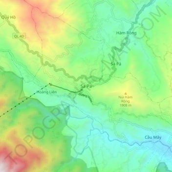
Name: Sa Pa topographic map, elevation, terrain.
Location: Sa Pa, Phường Sa Pa, Lào Cai Province, 31786, Vietnam (22.29592 103.80237 22.37592 103.88237)
Average elevation: 1,521 m
Minimum elevation: 979 m
Maximum elevation: 2,734 m
Thank you for supporting this site ❤️
Make a donation
Make a donation
Gear up for your next adventure:
As an Amazon Associate, this site earns from qualifying purchases at no extra cost to you.