
Ada County topographic map
Interactive map
Click on the map to display elevation.
About this map
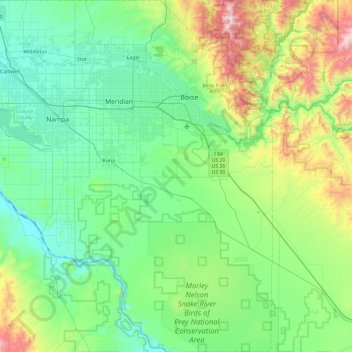
Name: Ada County topographic map, elevation, terrain.
Location: Ada County, Idaho, United States (43.11227 -116.51370 43.80742 -115.97486)
Average elevation: 1,003 m
Minimum elevation: 680 m
Maximum elevation: 2,279 m
Other topographic maps
Click on a map to view its topography, its elevation and its terrain.
Arco
United States > Idaho > Butte County
Arco, Butte County, Idaho, 83213, United States
Average elevation: 1,634 m
Kuna
United States > Idaho > Ada County
Kuna, Ada County, Idaho, United States
Average elevation: 830 m
Miller Water Table
United States > Idaho > Owyhee County
Miller Water Table, Owyhee County, Idaho, United States
Average elevation: 1,140 m
Big Clear lake
United States > Idaho > Lemhi County
Big Clear lake, Lemhi County, Idaho, United States
Average elevation: 2,617 m
Stanley
United States > Idaho > Custer County
Stanley, Custer County, Idaho, United States
Average elevation: 1,931 m
Chief
United States > Idaho > Valley County
Chief, Valley County, Idaho, United States
Average elevation: 2,249 m
Soda Springs
United States > Idaho > Caribou County
Soda Springs, Caribou County, Idaho, 83276, United States
Average elevation: 1,783 m
Idaho Falls
United States > Idaho > Bonneville County
Idaho Falls, Bonneville County, Idaho, United States
Average elevation: 1,441 m
Snake River
United States > Idaho > Washington County
Snake River, Washington County, Idaho, United States
Average elevation: 643 m
Boise
United States > Idaho > Ada County
Boise, Ada County, Idaho, 83701, United States
Average elevation: 1,040 m
Hagerman
United States > Idaho > Gooding County > Hagerman
Hagerman, Gooding County, Idaho, 83332, United States
Average elevation: 900 m
K Mountain
United States > Idaho > Lemhi County
K Mountain, Lemhi County, Idaho, United States
Average elevation: 2,120 m
Idaho Falls
United States > Idaho > Bonneville County > Idaho Falls
Idaho Falls, Bonneville County, Idaho, 83403, United States
Average elevation: 1,512 m
McCall
United States > Idaho > Valley County > McCall
McCall, Valley County, Idaho, 83638, United States
Average elevation: 1,546 m
Washington County
Washington County, Idaho, United States
Average elevation: 1,122 m
Corkscrew Mountain
Corkscrew Mountain, Idaho, United States
Average elevation: 2,459 m
Oneida County
United States > Idaho > Oneida County
Oneida County, Idaho, United States
Average elevation: 1,678 m
Ruth Lake
Ruth Lake, Adams County, Idaho, United States
Average elevation: 2,218 m
Newdale
United States > Idaho > Fremont County
Newdale, Fremont County, Idaho, 83436, United States
Average elevation: 1,550 m
Sandpoint
United States > Idaho > Sandpoint
Sandpoint, Bonner County, Idaho, 83864, United States
Average elevation: 658 m
Twin Falls County
Twin Falls County, Idaho, United States
Average elevation: 1,404 m
Bear Lake County
Bear Lake County, Idaho, United States
Average elevation: 2,095 m
Grangeville
United States > Idaho > Idaho County
Grangeville, Idaho County, Idaho, United States
Average elevation: 1,037 m
Idaho City
United States > Idaho > Boise County
Idaho City, Boise County, Idaho, 83631, United States
Average elevation: 1,236 m
Mud Lake
United States > Idaho > Jefferson County
Mud Lake, Jefferson County, Idaho, United States
Average elevation: 1,460 m
Snake River
United States > Idaho > Washington County
Snake River, Washington County, Idaho, United States
Average elevation: 643 m
Boise
United States > Idaho > Ada County
Boise, Ada County, Idaho, United States
Average elevation: 974 m
Bonneville County
Bonneville County, Idaho, United States
Average elevation: 1,963 m
Worley
United States > Idaho > Kootenai County
Worley, Kootenai County, Idaho, United States
Average elevation: 830 m
Nampa
United States > Idaho > Canyon County > Nampa
Nampa, Canyon County, Idaho, United States
Average elevation: 764 m