
Bingham County topographic map
Click on the map to display elevation.
About this map
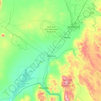
Name: Bingham County topographic map, elevation, terrain.
Location: Bingham County, Idaho, United States (42.86300 -113.00779 43.62663 -111.58597)
Average elevation: 1,580 m
Minimum elevation: 1,292 m
Maximum elevation: 2,766 m
Other topographic maps
Click on a map to view its topography, its elevation and its terrain.
Snake River
United States > Idaho > Washington County
Due to the rain shadow effect of the Cascades, precipitation as a whole is scant, averaging 14 inches (360 mm) across the entire watershed. Most precipitation falls at higher elevations as snow, thus, most runoff in the Snake River watershed derives from snowmelt. Jackson Hole, Wyoming experiences an alpine…
Average elevation: 644 m
Boise
United States > Idaho > Ada County
Boise (locally /ˈbɔɪsi/ BOY-see) is the capital and most populous city of the U.S. state of Idaho and is the county seat of Ada County. As of the 2020 census, there were 235,684 people residing in the city. On the Boise River in southwestern Idaho, it is 41 miles (66 km) east of the Oregon border and 110…
Average elevation: 1,040 m
Snake River
United States > Idaho > Washington County
Mountain ranges in the Snake watershed include the Teton Range, Bitterroot Range, Clearwater Mountains, Seven Devils Mountains, and the extreme northwestern end of the Wind River Range. Grand Teton is the highest point in the Snake River watershed, reaching 13,775 feet (4,199 m) in elevation. The elevation of…
Average elevation: 643 m