
McCall topographic map
Click on the map to display elevation.
McCall
Brundage Mountain, northwest of McCall, opened in November 1961. Brundage has a summit elevation of 7,803 feet (2,380 m) above sea level, and a vertical drop of 1,921 feet (590 m). The slopes on Brundage Mountain are primarily west-facing and the mountain's average snowfall exceeds 320 inches (810 cm). It currently has five chairlifts and one Magic Carpet (two high-speed quad chairs, three triple chairs, and one magic carpet) with a capacity of 9,000 people per hour. The lifts afford access to 1920 acres of terrain, including 420 acres of lift-accessed, un-patrolled, without avalanche mitigation, backcountry terrain. The resort also operates a backcountry snowcat skiing operation which provides guided access to 18,000 acres (73 km2) of untracked powder in the Payette National Forest north of the ski area. There are also three terrain parks of varying difficulty. Summer activities include lift-served mountain biking trails, scenic chairlift rides, summer concerts, yoga and other calendared events. Brundage was owned by the DeBoer family, descendants of early McCall pioneers, with J. R. Simplot. In April 2016, the DeBoers took full control of the property, purchasing the 50% interest of the his family. In 2020, ownership was transferred to Brundage Mountain Holdings with the DeBoer family maintaining an ownership stake.
About this map
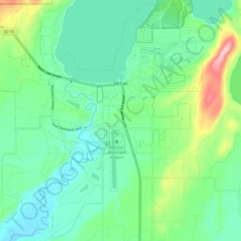
Name: McCall topographic map, elevation, terrain.
Location: McCall, Valley County, Idaho, 83638, United States (44.86605 -116.16411 44.93408 -116.06501)
Average elevation: 1,546 m
Minimum elevation: 1,491 m
Maximum elevation: 1,703 m
Other topographic maps
Click on a map to view its topography, its elevation and its terrain.