
Make a donation
Gear up for your next adventure:
As an Amazon Associate, this site earns from qualifying purchases at no extra cost to you.
Ruth Lake topographic map
Click on the map to display elevation.
Make a donation
Gear up for your next adventure:
As an Amazon Associate, this site earns from qualifying purchases at no extra cost to you.
About this map
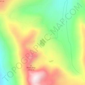
Name: Ruth Lake topographic map, elevation, terrain.
Location: Ruth Lake, Adams County, Idaho, United States (45.24092 -116.55845 45.24334 -116.55586)
Average elevation: 2,218 m
Minimum elevation: 1,843 m
Maximum elevation: 2,673 m
Make a donation
Gear up for your next adventure:
As an Amazon Associate, this site earns from qualifying purchases at no extra cost to you.
Other topographic maps
Click on a map to view its topography, its elevation and its terrain.
Elmore County
According to the U.S. Census Bureau, the county has a total area of 3,101 square miles (8,030 km2), of which 3,075 square miles (7,960 km2) is land and 26 square miles (67 km2) (0.8%) is water. Elmore County's highest point is Snowyside Peak at 10,651 feet (3,246 m) above sea level, located in the northeast…
Average elevation: 1,441 m
Hayden
United States > Idaho > Kootenai County
According to the United States Census Bureau, the city has a total area of 9.61 square miles (24.89 km2), of which 9.60 square miles (24.86 km2) is land and 0.01 square miles (0.03 km2) is water. It lies at the southwestern end of Hayden Lake, and the elevation of the city is 2,287 feet (697 m) above sea level.
Average elevation: 709 m
Ketchum
United States > Idaho > Blaine County
After the mining boom subsided in the 1890s, sheepmen from the south drove their flocks north through Ketchum in the summer, to graze in the upper elevation areas of the Pioneer, Boulder, and Sawtooth mountains. By 1920, Ketchum had become the largest sheep-shipping center in the West. In the fall, massive…
Average elevation: 1,906 m
Make a donation
Gear up for your next adventure:
As an Amazon Associate, this site earns from qualifying purchases at no extra cost to you.
Stanley
United States > Idaho > Custer County
Stanley is located at 44°13′0″N 114°56′16″W / 44.21667°N 114.93778°W / 44.21667; -114.93778 (44.216698, -114.937814), at an elevation of 6,253 feet (1,906 m) above sea level
Average elevation: 1,931 m
Arco
United States > Idaho > Butte County
Arco Peak, located two mile north of the community at an elevation of 7547 feet, rises 2220 feet above the city.
Average elevation: 1,634 m
Make a donation
Gear up for your next adventure:
As an Amazon Associate, this site earns from qualifying purchases at no extra cost to you.
Oneida County
United States > Idaho > Oneida County
Oxford Peak is the highest point in the county at 9,285 ft (2830.2 m) above sea level. Alternating valleys and ridges of mountains or hills typify the topography, with grassland and sagebrush covering most areas. The Curlew National Grassland lies within the county.
Average elevation: 1,678 m
Make a donation
Gear up for your next adventure:
As an Amazon Associate, this site earns from qualifying purchases at no extra cost to you.
Make a donation
Gear up for your next adventure:
As an Amazon Associate, this site earns from qualifying purchases at no extra cost to you.
Boise
United States > Idaho > Ada County
Boise (locally /ˈbɔɪsi/ BOY-see) is the capital and most populous city of the U.S. state of Idaho and is the county seat of Ada County. As of the 2020 census, there were 235,684 people residing in the city. On the Boise River in southwestern Idaho, it is 41 miles (66 km) east of the Oregon border and 110…
Average elevation: 1,040 m