
Isen topographic map
Click on the map to display elevation.
About this map
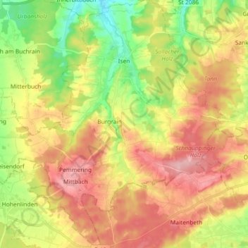
Name: Isen topographic map, elevation, terrain.
Location: Isen, Landkreis Erding, Bayern, 84424, Deutschland (48.13968 12.00211 48.23565 12.11623)
Average elevation: 563 m
Minimum elevation: 482 m
Maximum elevation: 642 m
Other topographic maps
Click on a map to view its topography, its elevation and its terrain.
Schnaupping
Deutschland > Bayern > Landkreis Erding > Taufkirchen > Angerskirchen > Schnaupping
Average elevation: 488 m
Unterhausmehring
Deutschland > Bayern > Landkreis Erding > Dorfen > Kloster Moosen
Average elevation: 466 m
Pfaffing bei Watzling
Deutschland > Bayern > Landkreis Erding > Dorfen > Watzling
Average elevation: 481 m
Kienraching
Deutschland > Bayern > Landkreis Erding > Taufkirchen > Angerskirchen
Average elevation: 489 m