Geolocate

Lappach topographic map

Click on the map to display elevation.

About this map

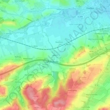
Name: Lappach topographic map, elevation, terrain.

Location: Lappach, Dorfen, Landkreis Erding, Bayern, 84405, Deutschland (48.23759 12.11381 48.27759 12.15381)

Average elevation: 478 m

Minimum elevation: 436 m

Maximum elevation: 551 m

Gear up for your next adventure:

🔭Compact Binoculars - Lightweight optics for scouting trails and wildlife
🧦Hiking Liner Socks - Thin base layer to prevent friction and blisters
🧢Outdoor Cap - Protective cap for sun and rain during hikes
🥾Mountaineering Boots - Supportive boots for climbing and high-altitude hiking
🔨Vehicle Emergency Tool - Safety tool for remote road trips to trailheads

As an Amazon Associate, this site earns from qualifying purchases at no extra cost to you.