Geolocate

Mais topographic map

Click on the map to display elevation.

About this map

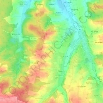
Name: Mais topographic map, elevation, terrain.

Location: Mais, Isen, Landkreis Erding, Bayern, 84424, Deutschland (48.19020 12.02040 48.23020 12.06040)

Average elevation: 533 m

Minimum elevation: 485 m

Maximum elevation: 585 m

Gear up for your next adventure:

🍽️Titanium Camping Spork - Ultralight and indestructible eating utensil
🥾Waterproof Hiking Boots - Essential footwear for rugged terrain and wet Canadian trails
🥾Trail Running Shoes - Lightweight and durable shoes for trail running
🚲Heavy Duty Bike Lock - Secure your bike at the trailhead or during stops
🥾Trail Running Boots - Durable shoes designed for trail running

As an Amazon Associate, this site earns from qualifying purchases at no extra cost to you.