
Area D (Elaho/Garibaldi) topographic map
Interactive map
Click on the map to display elevation.
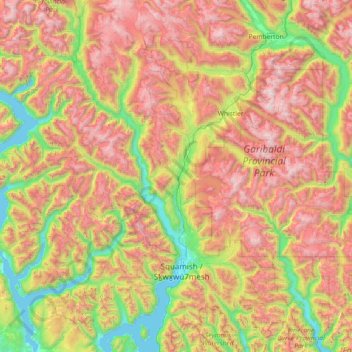
Area D (Elaho/Garibaldi) topographic map, elevation, terrain
About this map
Name: Area D (Elaho/Garibaldi) topographic map, elevation, terrain.
Average elevation: 1,137 m
Minimum elevation: -2 m
Maximum elevation: 2,843 m
Routes: Squamish-Lillooet Regional District GPS tracks, routes, trails, hikes
Other topographic maps
Click on a map to view its topography, its elevation and its terrain.
Pemberton
Canada > British Columbia > Squamish-Lillooet Regional District
The climate of Pemberton is very warm and dry in the summer and mild and wet in the winter. Pemberton is an ecologically complex and diverse zone which is referred to as the Coast-Interior Transition zone. Moving from west to east in the direction of the prevailing winds and taking into consideration the…
Average elevation: 1,005 m
Whistler
Canada > British Columbia > Squamish-Lillooet Regional District > Whistler Resort Municipality > Whistler
Average elevation: 996 m
Birkenhead Lake Provincial Park
Canada > British Columbia > Squamish-Lillooet Regional District > Area C (Pemberton Valley/Mount Currie/D'Arcy)
Average elevation: 1,558 m
The Black Tusk
Canada > British Columbia > Squamish-Lillooet Regional District > Area D (Elaho/Garibaldi)
Average elevation: 1,874 m
Joffre Lakes Provincial Park
Canada > British Columbia > Squamish-Lillooet Regional District > Area C (Pemberton Valley/Mount Currie/D'Arcy)
Staying on the trail is important for the preservation of the park environment, and for the safety of hikers. Lower Joffre Lake is a short distance away from the parking lot with no elevation gain. The trail to Middle and Upper Joffre lakes however is more challenging due to the greater elevation gain. Hiking…
Average elevation: 1,911 m
Cheekye River
Canada > British Columbia > Squamish-Lillooet Regional District > Area D (Elaho/Garibaldi)
Average elevation: 634 m
Bralorne
Canada > British Columbia > Squamish-Lillooet Regional District > Area A (Upper Bridge River Valley)
Average elevation: 1,255 m
Elfin Lakes
Canada > British Columbia > Squamish-Lillooet Regional District > Area D (Elaho/Garibaldi)
Average elevation: 1,331 m
Cirque Peak
Canada > British Columbia > Squamish-Lillooet Regional District > Area C (Pemberton Valley/Mount Currie/D'Arcy)
Average elevation: 1,999 m
Onion Peak
Canada > British Columbia > Squamish-Lillooet Regional District > Area B (Cayoosh/Pavilion)
Average elevation: 2,263 m
Gun Creek
Canada > British Columbia > Squamish-Lillooet Regional District > Area A (Upper Bridge River Valley)
Average elevation: 1,373 m
Lake La Mare Recreation Site
Canada > British Columbia > Squamish-Lillooet Regional District > Area B (Cayoosh/Pavilion)
Average elevation: 1,272 m
T'it'q'et First Nation
Canada > British Columbia > Squamish-Lillooet Regional District > Area B (Cayoosh/Pavilion)
Average elevation: 1,092 m
Nairn Falls
Canada > British Columbia > Squamish-Lillooet Regional District > Area C (Pemberton Valley/Mount Currie/D'Arcy)
Average elevation: 545 m
Exodus Peak
Canada > British Columbia > Squamish-Lillooet Regional District > Area C (Pemberton Valley/Mount Currie/D'Arcy)
Average elevation: 2,115 m
Stawamus Chief Provincial Park
Canada > British Columbia > Squamish-Lillooet Regional District > Squamish
Average elevation: 433 m
Anderson Lake
Canada > British Columbia > Squamish-Lillooet Regional District > Area B (Cayoosh/Pavilion)
Average elevation: 1,330 m
Mount Brew
Canada > British Columbia > Squamish-Lillooet Regional District > Area D (Elaho/Garibaldi)
Average elevation: 1,513 m
Lillooet Lake
Canada > British Columbia > Squamish-Lillooet Regional District > Area C (Pemberton Valley/Mount Currie/D'Arcy)
Average elevation: 1,177 m
Minaty Bay
Canada > British Columbia > Squamish-Lillooet Regional District > Area D (Elaho/Garibaldi)
Average elevation: 91 m
Mount Aragorn
Canada > British Columbia > Squamish-Lillooet Regional District > Area A (Upper Bridge River Valley)
Average elevation: 2,115 m
Chipmunk Mountain West Peak
Canada > British Columbia > Squamish-Lillooet Regional District > Area A (Upper Bridge River Valley)
Average elevation: 1,964 m
Brexton
Canada > British Columbia > Squamish-Lillooet Regional District > Area A (Upper Bridge River Valley)
Average elevation: 975 m
Carpenter Lake
Canada > British Columbia > Squamish-Lillooet Regional District > Area A (Upper Bridge River Valley)
Average elevation: 1,592 m
Garibaldi Lake
Canada > British Columbia > Squamish-Lillooet Regional District > Area D (Elaho/Garibaldi)
All recreational activities in the area are governed by the regulations of Garibaldi Provincial Park. Primary access to the lake is via the 9 km (5.5 mi) long Garibaldi Lake Trail, which gains approximately 920 m (3,020 ft) of elevation from the Rubble Creek Trailhead. There are campgrounds and day-use…
Average elevation: 1,620 m
Britannia Beach
Canada > British Columbia > Squamish-Lillooet Regional District > Area D (Elaho/Garibaldi)
Average elevation: 208 m
Garibaldi
Canada > British Columbia > Squamish-Lillooet Regional District > Area D (Elaho/Garibaldi)
Average elevation: 417 m
Whistler Village
Canada > British Columbia > Squamish-Lillooet Regional District > Whistler
Average elevation: 775 m
Chimney Rock
Canada > British Columbia > Squamish-Lillooet Regional District > Area B (Cayoosh/Pavilion)
Average elevation: 1,506 m
Tonic Peak
Canada > British Columbia > Squamish-Lillooet Regional District > Whistler Resort Municipality
Average elevation: 1,586 m
Panorama Ridge
Canada > British Columbia > Squamish-Lillooet Regional District > Area D (Elaho/Garibaldi)
Average elevation: 1,786 m
Deeks Lake
Canada > British Columbia > Squamish-Lillooet Regional District > Area D (Elaho/Garibaldi)
Average elevation: 1,237 m
Aussichtspunkt auf Lilloet und Fluss
Canada > British Columbia > Squamish-Lillooet Regional District > Lillooet
Average elevation: 510 m
Area A (Upper Bridge River Valley)
Canada > British Columbia > Squamish-Lillooet Regional District
Average elevation: 1,734 m
Furry Creek
Canada > British Columbia > Squamish-Lillooet Regional District > Area D (Elaho/Garibaldi)
Average elevation: 224 m
Cheakamus River
Canada > British Columbia > Squamish-Lillooet Regional District > Squamish
Average elevation: 266 m
Pemberton Meadows
Canada > British Columbia > Squamish-Lillooet Regional District > Area C (Pemberton Valley/Mount Currie/D'Arcy) > Pemberton Meadows
Average elevation: 480 m
Gold Bridge
Canada > British Columbia > Squamish-Lillooet Regional District > Area A (Upper Bridge River Valley)
Average elevation: 886 m
Barrier Lake
Canada > British Columbia > Squamish-Lillooet Regional District > Area D (Elaho/Garibaldi)
Average elevation: 1,405 m
Gun Lake
Canada > British Columbia > Squamish-Lillooet Regional District > Area A (Upper Bridge River Valley)
Average elevation: 1,049 m
Mount Price
Canada > British Columbia > Squamish-Lillooet Regional District > Area D (Elaho/Garibaldi)
Mount Price is a small stratovolcano in the Garibaldi Ranges of the Pacific Ranges in southwestern British Columbia, Canada. It has an elevation of 2,049 metres (6,722 feet) and rises above the surrounding landscape on the western side of Garibaldi Lake in New Westminster Land District. The mountain contains a…
Average elevation: 1,672 m
Mount Tantalus
Canada > British Columbia > Squamish-Lillooet Regional District > Area D (Elaho/Garibaldi)
Average elevation: 1,948 m
Area C (Pemberton Valley/Mount Currie/D'Arcy)
Canada > British Columbia > Squamish-Lillooet Regional District
Average elevation: 1,471 m
Birken
Canada > British Columbia > Squamish-Lillooet Regional District > Area C (Pemberton Valley/Mount Currie/D'Arcy)
Average elevation: 796 m
Area B (Cayoosh/Pavilion)
Canada > British Columbia > Squamish-Lillooet Regional District
Average elevation: 1,483 m
Brandywine Mountain
Canada > British Columbia > Squamish-Lillooet Regional District > Area D (Elaho/Garibaldi)
Average elevation: 1,897 m