
Stawamus Chief Provincial Park topographic map
Interactive map
Click on the map to display elevation.
About this map
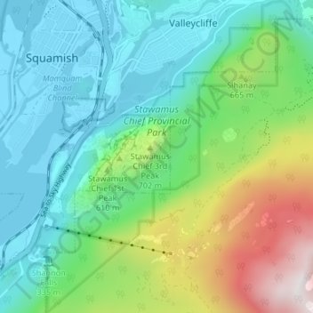
Name: Stawamus Chief Provincial Park topographic map, elevation, terrain.
Average elevation: 433 m
Minimum elevation: -7 m
Maximum elevation: 1,605 m
Other topographic maps
Click on a map to view its topography, its elevation and its terrain.
Cheakamus River
Canada > British Columbia > Squamish-Lillooet Regional District > Squamish
Cheakamus River, Cheakamus, Squamish, Squamish-Lillooet Regional District, British Columbia, V0N 0A4, Canada
Average elevation: 266 m