
Pemberton topographic map
Click on the map to display elevation.
Pemberton
The climate of Pemberton is very warm and dry in the summer and mild and wet in the winter. Pemberton is an ecologically complex and diverse zone which is referred to as the Coast-Interior Transition zone. Moving from west to east in the direction of the prevailing winds and taking into consideration the elevation changes; it follows that there is a windward, wetter zone and a leeward drier zone and an even drier zone on the leeward side of the Lillooet Ranges and the Pacific Ranges north of the rail line. High summer temperatures and the pronounced water deficits during the growing season are the norm.
About this map
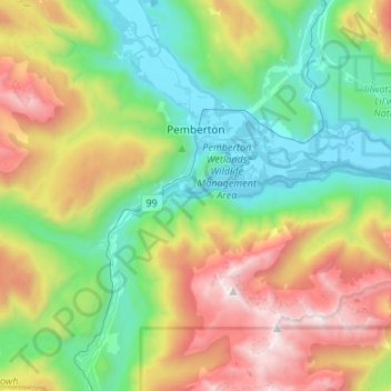
Name: Pemberton topographic map, elevation, terrain.
Average elevation: 1,005 m
Minimum elevation: 199 m
Maximum elevation: 2,579 m
Squamish-Lillooet Regional District trails, hiking, mountain biking, running and outdoor activities
Other topographic maps
Click on a map to view its topography, its elevation and its terrain.
Aussichtspunkt auf Lilloet und Fluss
Canada > British Columbia > Squamish-Lillooet Regional District > Lillooet
Average elevation: 510 m
Exodus Peak
Canada > British Columbia > Squamish-Lillooet Regional District > Area C (Pemberton Valley/Mount Currie/D'Arcy)
Average elevation: 2,115 m
Whistler
Canada > British Columbia > Squamish-Lillooet Regional District > Whistler Resort Municipality > Whistler
Average elevation: 996 m
Britannia Beach
Canada > British Columbia > Squamish-Lillooet Regional District > Area D (Elaho/Garibaldi)
Average elevation: 208 m
Lake La Mare Recreation Site
Canada > British Columbia > Squamish-Lillooet Regional District > Area B (Cayoosh/Pavilion)
Average elevation: 1,272 m
Elfin Lakes
Canada > British Columbia > Squamish-Lillooet Regional District > Area D (Elaho/Garibaldi)
Average elevation: 1,331 m
Cirque Peak
Canada > British Columbia > Squamish-Lillooet Regional District > Area C (Pemberton Valley/Mount Currie/D'Arcy)
Average elevation: 1,999 m
Bralorne
Canada > British Columbia > Squamish-Lillooet Regional District > Area A (Upper Bridge River Valley)
Average elevation: 1,255 m
Cheekye River
Canada > British Columbia > Squamish-Lillooet Regional District > Area D (Elaho/Garibaldi)
Average elevation: 634 m
The Black Tusk
Canada > British Columbia > Squamish-Lillooet Regional District > Area D (Elaho/Garibaldi)
Average elevation: 1,874 m
Spruce Lake
Canada > British Columbia > Squamish-Lillooet Regional District > Area A (Upper Bridge River Valley)
Average elevation: 1,688 m
Brandywine
Canada > British Columbia > Squamish-Lillooet Regional District > Area D (Elaho/Garibaldi)
Average elevation: 515 m
The Black Tusk (True Summit)
Canada > British Columbia > Squamish-Lillooet Regional District > Area D (Elaho/Garibaldi)
Average elevation: 1,875 m
D'Arcy
Canada > British Columbia > Squamish-Lillooet Regional District > Area C (Pemberton Valley/Mount Currie/D'Arcy)
Average elevation: 461 m
Slhanay
Canada > British Columbia > Squamish-Lillooet Regional District > Area D (Elaho/Garibaldi)
Average elevation: 363 m
Edith Lake
Canada > British Columbia > Squamish-Lillooet Regional District > Squamish
Average elevation: 309 m
Alice Lake
Canada > British Columbia > Squamish-Lillooet Regional District > Squamish
Average elevation: 247 m
Birken
Canada > British Columbia > Squamish-Lillooet Regional District > Area C (Pemberton Valley/Mount Currie/D'Arcy)
Average elevation: 796 m
Mount Sproatt
Canada > British Columbia > Squamish-Lillooet Regional District > Whistler
Average elevation: 1,533 m
Mount Price
Canada > British Columbia > Squamish-Lillooet Regional District > Area D (Elaho/Garibaldi)
Mount Price is a small stratovolcano in the Garibaldi Ranges of the Pacific Ranges in southwestern British Columbia, Canada. It has an elevation of 2,049 metres (6,722 feet) and rises above the surrounding landscape on the western side of Garibaldi Lake in New Westminster Land District. The mountain contains a…
Average elevation: 1,672 m
Moha
Canada > British Columbia > Squamish-Lillooet Regional District > Area B (Cayoosh/Pavilion)
Average elevation: 706 m
Barrier Lake
Canada > British Columbia > Squamish-Lillooet Regional District > Area D (Elaho/Garibaldi)
Average elevation: 1,405 m
Pemberton Meadows
Canada > British Columbia > Squamish-Lillooet Regional District > Area C (Pemberton Valley/Mount Currie/D'Arcy) > Pemberton Meadows
Average elevation: 480 m
Whistler Village
Canada > British Columbia > Squamish-Lillooet Regional District > Whistler
Average elevation: 775 m
Furry Creek
Canada > British Columbia > Squamish-Lillooet Regional District > Area D (Elaho/Garibaldi)
Average elevation: 224 m
Cheakamus River
Canada > British Columbia > Squamish-Lillooet Regional District > Squamish
Average elevation: 266 m
Panorama Ridge
Canada > British Columbia > Squamish-Lillooet Regional District > Area D (Elaho/Garibaldi)
Average elevation: 1,786 m
Deeks Lake
Canada > British Columbia > Squamish-Lillooet Regional District > Area D (Elaho/Garibaldi)
Average elevation: 1,237 m
Garibaldi
Canada > British Columbia > Squamish-Lillooet Regional District > Area D (Elaho/Garibaldi)
Average elevation: 417 m
Brexton
Canada > British Columbia > Squamish-Lillooet Regional District > Area A (Upper Bridge River Valley)
Average elevation: 975 m
Chipmunk Mountain West Peak
Canada > British Columbia > Squamish-Lillooet Regional District > Area A (Upper Bridge River Valley)
Average elevation: 1,964 m
Mount Aragorn
Canada > British Columbia > Squamish-Lillooet Regional District > Area A (Upper Bridge River Valley)
Average elevation: 2,115 m
Minaty Bay
Canada > British Columbia > Squamish-Lillooet Regional District > Area D (Elaho/Garibaldi)
Average elevation: 91 m
Mount Brew
Canada > British Columbia > Squamish-Lillooet Regional District > Area D (Elaho/Garibaldi)
Average elevation: 1,513 m
Nairn Falls
Canada > British Columbia > Squamish-Lillooet Regional District > Area C (Pemberton Valley/Mount Currie/D'Arcy)
Average elevation: 545 m
Gun Creek
Canada > British Columbia > Squamish-Lillooet Regional District > Area A (Upper Bridge River Valley)
Average elevation: 1,373 m
Onion Peak
Canada > British Columbia > Squamish-Lillooet Regional District > Area B (Cayoosh/Pavilion)
Average elevation: 2,263 m
Metal Dome
Canada > British Columbia > Squamish-Lillooet Regional District > Area D (Elaho/Garibaldi)
Average elevation: 1,678 m
Seton Portage
Canada > British Columbia > Squamish-Lillooet Regional District > Area B (Cayoosh/Pavilion)
Average elevation: 523 m
Mount Fergusson
Canada > British Columbia > Squamish-Lillooet Regional District > Area A (Upper Bridge River Valley)
Average elevation: 2,156 m
Mount Sloan
Canada > British Columbia > Squamish-Lillooet Regional District > Area A (Upper Bridge River Valley)
Average elevation: 2,089 m
Whistler Mountain
Canada > British Columbia > Squamish-Lillooet Regional District > Whistler
There is a weather station near the summit of Whistler Mountain at the Roundhouse Lodge, located at an elevation of 1835 m (6020 ft). Whistler Roundhouse has a dry-summer subalpine climate (Köppen Dsc), bordering on an Alpine climate (Köppen ET).
Average elevation: 1,810 m
Marble Canyon
Canada > British Columbia > Squamish-Lillooet Regional District > Area B (Cayoosh/Pavilion)
Average elevation: 1,141 m
Gin Peak
Canada > British Columbia > Squamish-Lillooet Regional District > Area C (Pemberton Valley/Mount Currie/D'Arcy)
Average elevation: 1,518 m
Locomotive Mountain
Canada > British Columbia > Squamish-Lillooet Regional District > Area C (Pemberton Valley/Mount Currie/D'Arcy)
Average elevation: 1,951 m
Gold Bridge
Canada > British Columbia > Squamish-Lillooet Regional District > Area A (Upper Bridge River Valley)
Average elevation: 886 m
Mount Meager
Canada > British Columbia > Squamish-Lillooet Regional District > Area C (Pemberton Valley/Mount Currie/D'Arcy)
Average elevation: 2,110 m
Whistler Olympic Park
Canada > British Columbia > Squamish-Lillooet Regional District > Area D (Elaho/Garibaldi)
Average elevation: 954 m
Wedgemount Falls
Canada > British Columbia > Squamish-Lillooet Regional District > Area C (Pemberton Valley/Mount Currie/D'Arcy)
Average elevation: 1,913 m
Mount Rohr
Canada > British Columbia > Squamish-Lillooet Regional District > Area B (Cayoosh/Pavilion)
Average elevation: 1,940 m
Sunshine Mountain
Canada > British Columbia > Squamish-Lillooet Regional District > Area A (Upper Bridge River Valley)
Average elevation: 1,965 m
Mount Cayley
Canada > British Columbia > Squamish-Lillooet Regional District > Area D (Elaho/Garibaldi)
Mount Cayley is an eroded but potentially active stratovolcano in the Pacific Ranges of southwestern British Columbia, Canada. Located 45 km (28 mi) north of Squamish and 24 km (15 mi) west of Whistler, the volcano resides on the edge of the Powder Mountain Icefield. It consists of massif that towers over the…
Average elevation: 1,896 m
Helm Glacier
Canada > British Columbia > Squamish-Lillooet Regional District > Area D (Elaho/Garibaldi)
Average elevation: 1,949 m
Sentinel Glacier
Canada > British Columbia > Squamish-Lillooet Regional District > Area D (Elaho/Garibaldi)
Average elevation: 1,856 m
The Table
Canada > British Columbia > Squamish-Lillooet Regional District > Area D (Elaho/Garibaldi)
Average elevation: 1,623 m
Mount Fee
Canada > British Columbia > Squamish-Lillooet Regional District > Area D (Elaho/Garibaldi)
Mount Fee is a volcanic peak in the Pacific Ranges of the Coast Mountains in southwestern British Columbia, Canada. It is located 13 km (8.1 mi) south of Callaghan Lake and 21 km (13 mi) west of the resort town of Whistler. With a summit elevation of 2,162 m (7,093 ft) and a topographic prominence of 312 m…
Average elevation: 1,771 m
Mount Callaghan
Canada > British Columbia > Squamish-Lillooet Regional District > Area C (Pemberton Valley/Mount Currie/D'Arcy)
Average elevation: 2,076 m
Ring Mountain
Canada > British Columbia > Squamish-Lillooet Regional District > Area D (Elaho/Garibaldi)
Average elevation: 1,816 m
Chimney Rock
Canada > British Columbia > Squamish-Lillooet Regional District > Area B (Cayoosh/Pavilion)
Average elevation: 1,506 m
Tonic Peak
Canada > British Columbia > Squamish-Lillooet Regional District > Whistler Resort Municipality
Average elevation: 1,586 m
Whistler Village
Canada > British Columbia > Squamish-Lillooet Regional District > Whistler
Average elevation: 775 m
Whistler Mountain
Canada > British Columbia > Squamish-Lillooet Regional District > Whistler
There is a weather station near the summit of Whistler Mountain at the Roundhouse Lodge, located at an elevation of 1835 m (6020 ft). Whistler Roundhouse has a dry-summer subalpine climate (Köppen Dsc), bordering on an Alpine climate (Köppen ET).
Average elevation: 1,810 m
Mount Currie
Canada > British Columbia > Squamish-Lillooet Regional District > Area C (Pemberton Valley/Mount Currie/D'Arcy)
Average elevation: 2,107 m
Watts Point
Canada > British Columbia > Squamish-Lillooet Regional District > Squamish
Average elevation: 44 m
Beacon Mountain
Canada > British Columbia > Squamish-Lillooet Regional District > Area C (Pemberton Valley/Mount Currie/D'Arcy)
Average elevation: 1,496 m
Mount Rohr
Canada > British Columbia > Squamish-Lillooet Regional District > Area B (Cayoosh/Pavilion)
Average elevation: 1,940 m
Furry Creek
Canada > British Columbia > Squamish-Lillooet Regional District > Area D (Elaho/Garibaldi)
Average elevation: 224 m
The Galapagos Islands Boulder
Canada > British Columbia > Squamish-Lillooet Regional District > Squamish
Average elevation: 289 m
Little Big Horn
Canada > British Columbia > Squamish-Lillooet Regional District > Area A (Upper Bridge River Valley)
Average elevation: 1,986 m
Soprano Peak
Canada > British Columbia > Squamish-Lillooet Regional District > Area B (Cayoosh/Pavilion)
Average elevation: 2,137 m
Mount Meager
Canada > British Columbia > Squamish-Lillooet Regional District > Area C (Pemberton Valley/Mount Currie/D'Arcy)
Average elevation: 2,110 m
Lost Peak
Canada > British Columbia > Squamish-Lillooet Regional District > Area B (Cayoosh/Pavilion)
Average elevation: 2,176 m
The Table
Canada > British Columbia > Squamish-Lillooet Regional District > Area D (Elaho/Garibaldi)
Average elevation: 1,623 m
Furry Creek
Canada > British Columbia > Squamish-Lillooet Regional District > Area D (Elaho/Garibaldi)
Average elevation: 224 m
Ring Mountain
Canada > British Columbia > Squamish-Lillooet Regional District > Area D (Elaho/Garibaldi)
Average elevation: 1,816 m
Mt. Mulligan
Canada > British Columbia > Squamish-Lillooet Regional District > Area D (Elaho/Garibaldi)
Average elevation: 1,159 m
Beach Mountain
Canada > British Columbia > Squamish-Lillooet Regional District > Area C (Pemberton Valley/Mount Currie/D'Arcy)
Average elevation: 2,063 m
The Copilot
Canada > British Columbia > Squamish-Lillooet Regional District > Area D (Elaho/Garibaldi)
Average elevation: 1,466 m
Mount Meager
Canada > British Columbia > Squamish-Lillooet Regional District > Area C (Pemberton Valley/Mount Currie/D'Arcy)
Average elevation: 2,110 m
The Galapagos Islands Boulder
Canada > British Columbia > Squamish-Lillooet Regional District > Squamish
Average elevation: 289 m
Whistler Village
Canada > British Columbia > Squamish-Lillooet Regional District > Whistler
Average elevation: 775 m