
Make a donation
Gear up for your next adventure:
As an Amazon Associate, this site earns from qualifying purchases at no extra cost to you.
Whistler Village topographic map
Click on the map to display elevation.
Make a donation
Gear up for your next adventure:
As an Amazon Associate, this site earns from qualifying purchases at no extra cost to you.
About this map
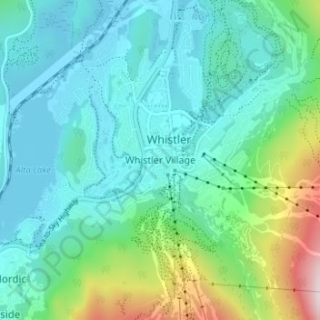
Name: Whistler Village topographic map, elevation, terrain.
Average elevation: 775 m
Minimum elevation: 637 m
Maximum elevation: 1,288 m
Squamish-Lillooet Regional District trails, hiking, mountain biking, running and outdoor activities
Make a donation
Gear up for your next adventure:
As an Amazon Associate, this site earns from qualifying purchases at no extra cost to you.
Other topographic maps
Click on a map to view its topography, its elevation and its terrain.
Alta Lake
Canada > British Columbia > Squamish-Lillooet Regional District > Whistler > Whistler Village
Originally named Summit Lake, Alta Lake was renamed to avoid confusion with the many other Summit Lakes in British Columbia. The name is derived from the Spanish for "high up" or "upper". The lake's southern end is the divide between the basins of the Green and Cheakamus Rivers. The lake is 642 metres (2,106…
Average elevation: 726 m