
Make a donation
Gear up for your next adventure:
As an Amazon Associate, this site earns from qualifying purchases at no extra cost to you.
Quảng Ninh Province topographic map
Click on the map to display elevation.
Make a donation
Gear up for your next adventure:
As an Amazon Associate, this site earns from qualifying purchases at no extra cost to you.
About this map
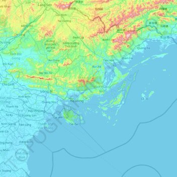
Name: Quảng Ninh Province topographic map, elevation, terrain.
Location: Quảng Ninh Province, Vietnam (20.46463 106.43915 21.66353 108.22329)
Average elevation: 122 m
Minimum elevation: -2 m
Maximum elevation: 1,438 m
Make a donation
Gear up for your next adventure:
As an Amazon Associate, this site earns from qualifying purchases at no extra cost to you.
Other topographic maps
Click on a map to view its topography, its elevation and its terrain.
Make a donation
Gear up for your next adventure:
As an Amazon Associate, this site earns from qualifying purchases at no extra cost to you.
Đồng Hới
Vietnam > Quang Binh province > Đồng Hới > Đồng Hới
The city has diverse topographical and geological features, including hill, mountainous, half mountainous, coastal plains and coastal sand dunes.
Average elevation: 53 m
Make a donation
Gear up for your next adventure:
As an Amazon Associate, this site earns from qualifying purchases at no extra cost to you.
Make a donation
Gear up for your next adventure:
As an Amazon Associate, this site earns from qualifying purchases at no extra cost to you.