
Peñafiel topographic map
Interactive map
Click on the map to display elevation.
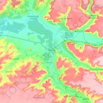
Peñafiel topographic map, elevation, terrain
About this map
Name: Peñafiel topographic map, elevation, terrain.
Location: Peñafiel, Valladolid, Castile and León, 47300, Spain (41.54976 -4.22444 41.64233 -4.04123)
Average elevation: 824 m
Minimum elevation: 730 m
Maximum elevation: 923 m
Other topographic maps
Click on a map to view its topography, its elevation and its terrain.
Salamanca
The city is located at an altitude of 800 meters above sea level. The altitude of the municipality varies from 911 meters (Los Montalvos), in the southwest, and 763 meters in the last stretch in the municipality of the Tormes river.
Average elevation: 812 m
León
As for the temperatures, in general it is a cold climate due to the altitude and the abundance of frost (which persist from November to May), being more intense in the mountainous areas reaching -18 °C. Vega de Liordes, an enclave in the León sector of Picos de Europa belonging to the municipality of Posada…
Average elevation: 913 m
Valladolid
Valladolid is located at roughly 735 metres above sea level, at the centre of the Meseta Norte, the plateau drained by the Duero river basin covering a major part of the Northwest of the Iberian Peninsula. The primitive urban core was built ex novo in the 11th century on a small elevation near the confluence…
Average elevation: 768 m
Burgos
At an elevation of 865 metres (2,838 ft), the city of Burgos lies in the transition zone between a Warm-summer Mediterranean climate (Köppen Csb) and an Oceanic climate (Köppen Cfb), with some continental influence resulting from its distance from the sea and higher altitude. Burgos' climate features chilly…
Average elevation: 907 m