Geolocate

Milagros topographic map

Click on the map to display elevation.

About this map

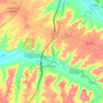
Name: Milagros topographic map, elevation, terrain.

Location: Milagros, Burgos, Castile and León, 09460, Spain (41.55204 -3.72071 41.61670 -3.64525)

Average elevation: 884 m

Minimum elevation: 827 m

Maximum elevation: 935 m

Other topographic maps

Click on a map to view its topography, its elevation and its terrain.

Camino de Santiago

Spain > Castile and León > Zazuar

Average elevation: 848 m

Toroño

Spain > Castile and León > Porto

Average elevation: 1,495 m

Río de la Mora

Spain > Castile and León > Navalacruz

Average elevation: 1,495 m

Sorriba del Esla

Spain > Castile and León > Cistierna

Average elevation: 1,021 m

Sahechores de Rueda

Spain > Castile and León

Average elevation: 885 m

Castroañe

Spain > Castile and León > Villaselán

Average elevation: 873 m

Castillo de Alba

Spain > Castile and León > Losacino

Average elevation: 745 m

Gear up for your next adventure:

Camping Tent - Weather-resistant tents suitable for 2 to 6 people
🧴Sunscreen SPF - Broad-spectrum sunscreen for outdoor activities
🧥Waterproof Pants - Keep dry during rainy hiking conditions
🌬️Windproof Camp Stove - Efficient cooking even on exposed mountain peaks
🧼Travel Hand Sanitizer - Keep hands clean when water is scarce

As an Amazon Associate, this site earns from qualifying purchases at no extra cost to you.