Geolocate

Cubillas de Rueda topographic map

Click on the map to display elevation.

About this map

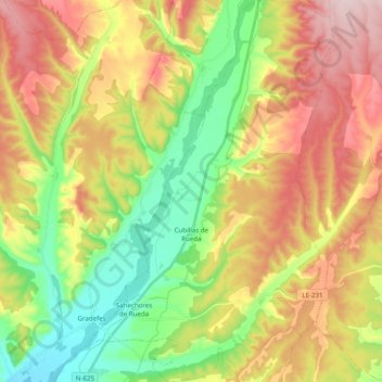
Name: Cubillas de Rueda topographic map, elevation, terrain.

Location: Cubillas de Rueda, León, Castile and León, Spain (42.60008 -5.22858 42.74449 -5.10180)

Average elevation: 972 m

Minimum elevation: 841 m

Maximum elevation: 1,130 m

Other topographic maps

Click on a map to view its topography, its elevation and its terrain.

Camino de Santiago

Spain > Castile and León > Zazuar

Average elevation: 848 m

Toroño

Spain > Castile and León > Porto

Average elevation: 1,495 m

Río de la Mora

Spain > Castile and León > Navalacruz

Average elevation: 1,495 m

Sorriba del Esla

Spain > Castile and León > Cistierna

Average elevation: 1,021 m

Sahechores de Rueda

Spain > Castile and León

Average elevation: 885 m

Castroañe

Spain > Castile and León > Villaselán

Average elevation: 873 m

Castillo de Alba

Spain > Castile and León > Losacino

Average elevation: 745 m

Gear up for your next adventure:

🥾Trail Hiking Shoes - Durable shoes designed for rugged trails
🥾Hiking Leggings - Comfortable leggings for outdoor activities
🥾Light Hiking Boots - Lightweight and comfortable boots for day hikes
🪜Heavy Duty Carabiners - Multi-use clips for securing gear to your backpack
🛏️Sleeping Bag - Warm and compact sleeping bags for outdoor camping

As an Amazon Associate, this site earns from qualifying purchases at no extra cost to you.