Geolocate

El Arenal topographic map

Click on the map to display elevation.

About this map

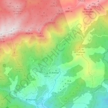
Name: El Arenal topographic map, elevation, terrain.

Location: El Arenal, Ávila, Castile and León, Spain (40.24527 -5.12273 40.31211 -5.05299)

Average elevation: 1,301 m

Minimum elevation: 659 m

Maximum elevation: 2,159 m

Gear up for your next adventure:

🧴Waterproofing Spray - Restore the DWR coating on jackets and tents
🥾Mountaineering Boots - Supportive boots for climbing and high-altitude hiking
🥾Trail Running Boots - Durable shoes designed for trail running
🧴Sunscreen SPF - Broad-spectrum sunscreen for outdoor activities
🛌Down Sleeping Bag - Superior warmth-to-weight ratio for cold nights

As an Amazon Associate, this site earns from qualifying purchases at no extra cost to you.