
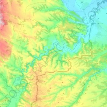
Bor Administrative District topographic map
Interactive map
Click on the map to display elevation.
Bor Administrative District topographic map, elevation, terrain
About this map
Name: Bor Administrative District topographic map, elevation, terrain.
Location: Bor Administrative District, Central Serbia, Serbia, Тимок (43.92012 22.29816 44.21554 22.67382)
Average elevation: 218 m
Minimum elevation: 35 m
Maximum elevation: 634 m
Other topographic maps
Click on a map to view its topography, its elevation and its terrain.
Zivkovci
Serbia > Central Serbia > Kolubara Administrative District > Ljig Municipality
Average elevation: 296 m
Bozurnja
Serbia > Central Serbia > Sumadija Administrative District > Topola Municipality
Average elevation: 233 m
Gornji Milanovac
Serbia > Central Serbia > Moravica Administrative District > Gornji Milanovac Municipality
Gornji Milanovac and the villages of Varnice, Zagradje, Dragolj and Trudelj are dominated by the Ostrvica Massif. The elevation of Ostrvica is 758 metres (2,487 ft). Ostrvica is actually the remains of a destroyed volcanic cone. In May 2009, Ostrvica was declared a natural monument. In the middle of the last…
Average elevation: 412 m
Brđani
Serbia > Central Serbia > Rasina Administrative District > Brus Municipality
Average elevation: 562 m
Barajevo
Serbia > Central Serbia > City of Belgrade > Barajevo Urban Municipality
The municipality is located in the lower northern part of Šumadija, southeast of the Belgrade, with an elevation spanning from 140 meters to 364 meters. Most of the municipal territory belongs to the drainage area of the Turija river, right tributary of the Peštan river, which in turn flows into the…
Average elevation: 175 m
Zdrelo
Serbia > Central Serbia > Branicevo Administrative District > Petrovac-na-Mlavi Municipality
Average elevation: 327 m
Ritopek
Serbia > Central Serbia > City of Belgrade > Grocka Urban Municipality
Average elevation: 116 m
Gruza Lake
Serbia > Central Serbia > Sumadija Administrative District > Knic Municipality
New spatial plan was proposed in 2011, but was never adopted. It included elevation of the water level and enlargement of the lake, but the residents of the bank villages protested, fearing they will end up being flooded. In March 2022, the government decided to make a new spatial plan for the area, which…
Average elevation: 306 m
Pruzatovac
Serbia > Central Serbia > City of Belgrade > Mladenovac Urban Municipality
Average elevation: 179 m
Brezovac
Serbia > Central Serbia > Sumadija Administrative District > Arandjelovac Municipality
Average elevation: 380 m
Stojnik
Serbia > Central Serbia > City of Belgrade > Sopot Urban Municipality
Average elevation: 230 m
Gruza
Serbia > Central Serbia > Sumadija Administrative District > Knic Municipality
Average elevation: 258 m
Arandjelovac
Serbia > Central Serbia > Sumadija Administrative District > Arandjelovac Municipality
Average elevation: 326 m
Kalanjevci
Serbia > Central Serbia > Kolubara Administrative District > Ljig Municipality
Average elevation: 279 m
Siljakovac
Serbia > Central Serbia > City of Belgrade > Barajevo Urban Municipality
Average elevation: 164 m
Progoreoci
Serbia > Central Serbia > Sumadija Administrative District > Arandjelovac Municipality
Average elevation: 262 m
Gornja Tresnjevica
Serbia > Central Serbia > Sumadija Administrative District > Arandjelovac Municipality
Average elevation: 385 m
Nemenikuce
Serbia > Central Serbia > City of Belgrade > Sopot Urban Municipality
Average elevation: 249 m
Sovljak
Serbia > Central Serbia > Kolubara Administrative District > Ub Municipality
Average elevation: 107 m
Vukosavci
Serbia > Central Serbia > Sumadija Administrative District > Arandjelovac Municipality
Average elevation: 388 m
Jagnjilo
Serbia > Central Serbia > City of Belgrade > Mladenovac Urban Municipality
Average elevation: 155 m
Ravna Gora
Serbia > Central Serbia > Jablanica Administrative District > Vlasotince Municipality
Average elevation: 877 m
Meljak
Serbia > Central Serbia > City of Belgrade > Barajevo Urban Municipality
Average elevation: 199 m
Guncati
Serbia > Central Serbia > City of Belgrade > Barajevo Urban Municipality
Average elevation: 189 m
Vrbica
Serbia > Central Serbia > Sumadija Administrative District > Arandjelovac Municipality
Average elevation: 373 m
Lisovic
Serbia > Central Serbia > City of Belgrade > Barajevo Urban Municipality
Average elevation: 206 m
Manic
Serbia > Central Serbia > City of Belgrade > Barajevo Urban Municipality
Average elevation: 177 m
Sovljak
Serbia > Central Serbia > Macva Administrative District > Bogatic Municipality
Average elevation: 83 m
Rusanj
Serbia > Central Serbia > City of Belgrade > Cukarica Urban Municipality
Average elevation: 207 m
Paljuvi
Serbia > Central Serbia > Kolubara Administrative District > Ub Municipality
Average elevation: 129 m
Vrhovine
Serbia > Central Serbia > Kolubara Administrative District > Ub Municipality
Average elevation: 198 m
Rakari
Serbia > Central Serbia > Kolubara Administrative District > Mionica Municipality
Average elevation: 209 m
Poljanice
Serbia > Central Serbia > Kolubara Administrative District > Ljig Municipality
Average elevation: 223 m
Dici
Serbia > Central Serbia > Kolubara Administrative District > Ljig Municipality
Average elevation: 273 m
Trlic
Serbia > Central Serbia > Kolubara Administrative District > Ub Municipality
Average elevation: 127 m
Koracica
Serbia > Central Serbia > City of Belgrade > Mladenovac Urban Municipality
Average elevation: 251 m
Mali Mirasevac
Serbia > Central Serbia > Sumadija Administrative District > Raca Municipality
Average elevation: 148 m
Bozdarevac
Serbia > Central Serbia > City of Belgrade > Barajevo Urban Municipality
Average elevation: 160 m
Ranilovic
Serbia > Central Serbia > Sumadija Administrative District > Arandjelovac Municipality
Average elevation: 198 m
Dragolj
Serbia > Central Serbia > Moravica Administrative District > Gornji Milanovac Municipality
Average elevation: 292 m
Kopljare
Serbia > Central Serbia > Sumadija Administrative District > Arandjelovac Municipality
Average elevation: 213 m