
Make a donation
Gear up for your next adventure:
As an Amazon Associate, this site earns from qualifying purchases at no extra cost to you.
Dragolj topographic map
Click on the map to display elevation.
Make a donation
Gear up for your next adventure:
As an Amazon Associate, this site earns from qualifying purchases at no extra cost to you.
About this map
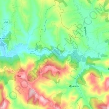
Name: Dragolj topographic map, elevation, terrain.
Average elevation: 292 m
Minimum elevation: 187 m
Maximum elevation: 466 m
Make a donation
Gear up for your next adventure:
As an Amazon Associate, this site earns from qualifying purchases at no extra cost to you.
Other topographic maps
Click on a map to view its topography, its elevation and its terrain.
Gornji Milanovac
Serbia > Central Serbia > Moravica Administrative District > Gornji Milanovac Municipality
Gornji Milanovac and the villages of Varnice, Zagradje, Dragolj and Trudelj are dominated by the Ostrvica Massif. The elevation of Ostrvica is 758 metres (2,487 ft). Ostrvica is actually the remains of a destroyed volcanic cone. In May 2009, Ostrvica was declared a natural monument. In the middle of the last…
Average elevation: 412 m
Ugrinovci
Serbia > Central Serbia > Moravica Administrative District > Gornji Milanovac Municipality
Average elevation: 344 m
Donja Crnuca
Serbia > Central Serbia > Moravica Administrative District > Gornji Milanovac Municipality
Average elevation: 399 m
Ozrem
Serbia > Central Serbia > Moravica Administrative District > Gornji Milanovac Municipality
Average elevation: 459 m
Make a donation
Gear up for your next adventure:
As an Amazon Associate, this site earns from qualifying purchases at no extra cost to you.