
Make a donation
Gear up for your next adventure:
As an Amazon Associate, this site earns from qualifying purchases at no extra cost to you.
Vrbica topographic map
Click on the map to display elevation.
Make a donation
Gear up for your next adventure:
As an Amazon Associate, this site earns from qualifying purchases at no extra cost to you.
About this map
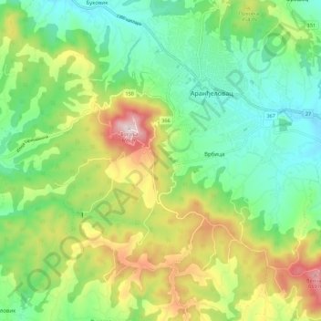
Name: Vrbica topographic map, elevation, terrain.
Average elevation: 373 m
Minimum elevation: 203 m
Maximum elevation: 688 m
Make a donation
Gear up for your next adventure:
As an Amazon Associate, this site earns from qualifying purchases at no extra cost to you.
Other topographic maps
Click on a map to view its topography, its elevation and its terrain.
Arandjelovac
Serbia > Central Serbia > Sumadija Administrative District > Arandjelovac Municipality
Average elevation: 326 m
Ranilovic
Serbia > Central Serbia > Sumadija Administrative District > Arandjelovac Municipality
Average elevation: 198 m
Bosuta
Serbia > Central Serbia > Sumadija Administrative District > Arandjelovac Municipality
Average elevation: 317 m
Vencane
Serbia > Central Serbia > Sumadija Administrative District > Arandjelovac Municipality
Average elevation: 178 m
Make a donation
Gear up for your next adventure:
As an Amazon Associate, this site earns from qualifying purchases at no extra cost to you.
Tulez
Serbia > Central Serbia > Sumadija Administrative District > Arandjelovac Municipality
Average elevation: 168 m
Kopljare
Serbia > Central Serbia > Sumadija Administrative District > Arandjelovac Municipality
Average elevation: 213 m