
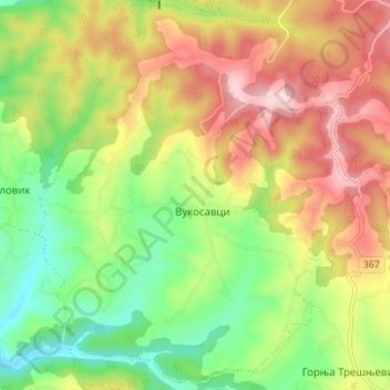
Vukosavci topographic map
Interactive map
Click on the map to display elevation.
About this map
Name: Vukosavci topographic map, elevation, terrain.
Average elevation: 388 m
Minimum elevation: 252 m
Maximum elevation: 548 m
Other topographic maps
Click on a map to view its topography, its elevation and its terrain.
Arandjelovac
Serbia > Central Serbia > Sumadija Administrative District > Arandjelovac Municipality
Average elevation: 326 m
Ranilovic
Serbia > Central Serbia > Sumadija Administrative District > Arandjelovac Municipality
Average elevation: 198 m
Kopljare
Serbia > Central Serbia > Sumadija Administrative District > Arandjelovac Municipality
Average elevation: 213 m
Tulez
Serbia > Central Serbia > Sumadija Administrative District > Arandjelovac Municipality
Average elevation: 168 m
Bosuta
Serbia > Central Serbia > Sumadija Administrative District > Arandjelovac Municipality
Average elevation: 317 m
Vencane
Serbia > Central Serbia > Sumadija Administrative District > Arandjelovac Municipality
Average elevation: 178 m