
Barajevo topographic map
Click on the map to display elevation.
Barajevo
The municipality is located in the lower northern part of Šumadija, southeast of the Belgrade, with an elevation spanning from 140 meters to 364 meters. Most of the municipal territory belongs to the drainage area of the Turija river, right tributary of the Peštan river, which in turn flows into the Kolubara, thus whole area geographically gravitates to the Kolubara region. The cultural festival, "Barlet" (Barajevo summer) is held annually in Barajevo.
About this map
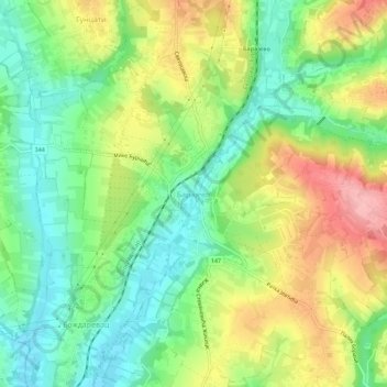
Name: Barajevo topographic map, elevation, terrain.
Average elevation: 175 m
Minimum elevation: 116 m
Maximum elevation: 261 m
Other topographic maps
Click on a map to view its topography, its elevation and its terrain.
Meljak
Serbia > Central Serbia > City of Belgrade > Barajevo Urban Municipality
Average elevation: 199 m