
Make a donation
Gear up for your next adventure:
As an Amazon Associate, this site earns from qualifying purchases at no extra cost to you.
Litchfield topographic map
Click on the map to display elevation.
Make a donation
Gear up for your next adventure:
As an Amazon Associate, this site earns from qualifying purchases at no extra cost to you.
About this map
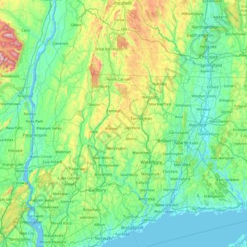
Name: Litchfield topographic map, elevation, terrain.
Location: Litchfield, Connecticut, 06750, United States (41.06725 -73.95430 42.46725 -72.55430)
Average elevation: 177 m
Minimum elevation: -4 m
Maximum elevation: 1,185 m
Make a donation
Gear up for your next adventure:
As an Amazon Associate, this site earns from qualifying purchases at no extra cost to you.
Other topographic maps
Click on a map to view its topography, its elevation and its terrain.
Litchfield County
United States > Connecticut > Northwest Hills Planning Region
Average elevation: 252 m
Madison
United States > Connecticut > South Central Connecticut Planning Region
Average elevation: 69 m
Bozrah Veterans Memorial
United States > Connecticut > Southeastern Connecticut Planning Region > Fitchville
Average elevation: 78 m
New Milford
United States > Connecticut > Western Connecticut Planning Region > New Milford
Average elevation: 160 m
Make a donation
Gear up for your next adventure:
As an Amazon Associate, this site earns from qualifying purchases at no extra cost to you.
New Haven
United States > Connecticut > South Central Connecticut Planning Region
Average elevation: 20 m
North Branford
United States > Connecticut > South Central Connecticut Planning Region
Average elevation: 68 m
West Hartford
United States > Connecticut > Capitol Planning Region
The west side of West Hartford is flanked by the Metacomet Ridge, a mountainous trap rock ridgeline that stretches from Long Island Sound to nearly the Vermont border. Notable features of the Metacomet Ridge in West Hartford include Talcott Mountain and a number of highland water reservoirs belonging to the…
Average elevation: 60 m
Make a donation
Gear up for your next adventure:
As an Amazon Associate, this site earns from qualifying purchases at no extra cost to you.
East Branch Eightmile River
United States > Connecticut > Southeastern Connecticut Planning Region > Salem
Average elevation: 83 m
Ridgefield
United States > Connecticut > Western Connecticut Planning Region
Ridgefield consists of hilly, rocky terrain, ranging from 1,060 feet (320 m) above sea level (at Pine Mountain) to 342 feet (104 m) at Branchville. Its average village elevation is 725 feet (221 m) above sea level. The landscape is strewn with countless rocks deposited by glaciers, and among the town's bodies…
Average elevation: 183 m
Putnam
United States > Connecticut > Northeastern Connecticut Planning Region
Average elevation: 123 m
Make a donation
Gear up for your next adventure:
As an Amazon Associate, this site earns from qualifying purchases at no extra cost to you.
Waterford
United States > Connecticut > Southeastern Connecticut Planning Region
Average elevation: 30 m
West Branch Naugatuck River
United States > Connecticut > Northwest Hills Planning Region > Torrington
Average elevation: 198 m
Glastonbury
United States > Connecticut > Capitol Planning Region
The town center experiences a humid continental climate (Dfa). However, the rural parts of the town, at an elevation of 800 feet near Bolton and Hebron, experience a colder climate which straddles the (Dfa) and (Dfb) lines.
Average elevation: 67 m
Make a donation
Gear up for your next adventure:
As an Amazon Associate, this site earns from qualifying purchases at no extra cost to you.
West Haven
United States > Connecticut > New Haven County > West Haven > West Haven
Average elevation: 21 m
Make a donation
Gear up for your next adventure:
As an Amazon Associate, this site earns from qualifying purchases at no extra cost to you.
Make a donation
Gear up for your next adventure:
As an Amazon Associate, this site earns from qualifying purchases at no extra cost to you.
Norwalk
United States > Connecticut > Western Connecticut COG
Norwalk's topography is dominated by its coastline along Long Island Sound, the Norwalk River and its eastern and western banks, and the Norwalk Islands. The highest elevation is 315 feet (96 m) above sea level on the fairway of the 16th hole of the Silvermine Golf Course, and the low elevation is sea level on…
Average elevation: 24 m
Make a donation
Gear up for your next adventure:
As an Amazon Associate, this site earns from qualifying purchases at no extra cost to you.
Derby
United States > Connecticut > New Haven County
According to the United States Census Bureau, the town has a total area of 5.4 square miles (8.7 km2), of which, 5.0 square miles (13 km2) is land and 0.4 square miles (1.0 km2) (7.41%) is water. The city is home to the 417 acres (0.652 sq mi) Osbornedale State Park. Derby is divided into two main sections by…
Average elevation: 77 m
Make a donation
Gear up for your next adventure:
As an Amazon Associate, this site earns from qualifying purchases at no extra cost to you.
Burr Pond State Park
United States > Connecticut > Litchfield County > Torrington > Burrville
Average elevation: 322 m