
Prince George's County topographic map
Interactive map
Click on the map to display elevation.
About this map
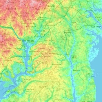
Name: Prince George's County topographic map, elevation, terrain.
Location: Prince George's County, Maryland, United States (38.53548 -77.08300 39.13190 -76.66929)
Average elevation: 45 m
Minimum elevation: -5 m
Maximum elevation: 173 m
Prince George's County lies in the Atlantic coastal plain, and its landscape is characterized by gently rolling hills and valleys. Along its western border with Montgomery County, Adelphi, Calverton and West Laurel rise into the piedmont, exceeding 300 feet (91 m) in elevation.
Other topographic maps
Click on a map to view its topography, its elevation and its terrain.
Lutherville
United States > Maryland > Baltimore County > Lutherville
Lutherville, Baltimore County, Maryland, United States
Average elevation: 116 m
Towson
United States > Maryland > Baltimore County
Towson, Baltimore County, Maryland, 21252, United States
Average elevation: 101 m
Saint Mary's County
Saint Mary's County, Maryland, United States
Average elevation: 13 m
Sunset Way
United States > Maryland > Carroll County
Sunset Way, Carroll County, Maryland, 21074, United States
Average elevation: 237 m
Westover
United States > Maryland > Somerset County
Westover, Somerset County, Maryland, 21890, United States
Average elevation: 4 m
Essex
United States > Maryland > Baltimore County
Essex, Baltimore County, Maryland, 21221, United States
Average elevation: 14 m
Lowrys Resurvey
United States > Maryland > Calvert County
Lowrys Resurvey, Calvert County, Maryland, United States
Average elevation: 29 m
Hyattsville
United States > Maryland > Prince George's County
Hyattsville, Prince George's County, Maryland, 20781, United States
Average elevation: 61 m
High Point
United States > Maryland > Anne Arundel County > Pasadena
High Point, Pasadena, Anne Arundel County, Maryland, 21122, United States
Average elevation: 12 m
Kingsville
United States > Maryland > Baltimore County
Kingsville, Baltimore County, Maryland, 21087, United States
Average elevation: 83 m
Springwood
United States > Maryland > Anne Arundel County > Jessup
Springwood, Jessup, Anne Arundel County, Maryland, 20794, United States
Average elevation: 63 m
Elkridge
United States > Maryland > Howard County
Elkridge, Howard County, Maryland, 21075, United States
Average elevation: 39 m
Turkey Point Park
United States > Maryland > Baltimore County > Dundalk > Turkey Point
Turkey Point Park, Bauernschmidt Manor, Turkey Point, Dundalk, Baltimore County, Maryland, United States
Average elevation: 2 m
Ellicott City
United States > Maryland > Howard County
Ellicott City, Howard County, Maryland, 21043, United States
Average elevation: 119 m
Dundalk
United States > Maryland > Baltimore County
Dundalk, Baltimore County, Maryland, 21222, United States
Average elevation: 33 m
Fairland
United States > Maryland > Montgomery County
Fairland, Montgomery County, Maryland, United States
Average elevation: 111 m
Benfield
United States > Maryland > Anne Arundel County > Glen Burnie
Benfield, Glen Burnie, Anne Arundel County, Maryland, 21108, United States
Average elevation: 25 m
Wetipquin
United States > Maryland > Wicomico County
Wetipquin, Wicomico County, Maryland, 21814, United States
Average elevation: 3 m
Salisbury
United States > Maryland > Wicomico County
Salisbury, Wicomico County, Maryland, United States
Average elevation: 12 m
Highland Beach
United States > Maryland > Anne Arundel County
Highland Beach, Anne Arundel County, Maryland, United States
Average elevation: 3 m
Germantown
United States > Maryland > Montgomery County
Germantown, Montgomery County, Maryland, 20874, United States
Average elevation: 136 m
Leeds
United States > Maryland > Anne Arundel County
Leeds, Anne Arundel County, Maryland, 21077, United States
Average elevation: 47 m
Druid Hill Park
United States > Maryland > Baltimore
Druid Hill Park, Park Heights, Baltimore, Maryland, United States
Average elevation: 78 m
Boones Mobile Estates
United States > Maryland > Anne Arundel County
Boones Mobile Estates, Anne Arundel County, Maryland, 20711, United States
Average elevation: 30 m
Sugarloaf Mountain
United States > Maryland > Frederick County > Stronghold
Sugarloaf Mountain, 7901, Comus Road, Stronghold, Frederick County, Maryland, 20842, United States
Average elevation: 161 m
Bird River
United States > Maryland > Baltimore County > Bowleys Quarters
Bird River, Bowleys Quarters, Baltimore County, Maryland, United States
Average elevation: 4 m
Bidle Hill Acres
United States > Maryland > Frederick County
Bidle Hill Acres, Frederick County, Maryland, 21173, United States
Average elevation: 184 m
Altogether
United States > Maryland > Frederick County > Thurmont
Altogether, Thurmont, Frederick County, Maryland, 21788, United States
Average elevation: 231 m
Casselman Bridge State Park
United States > Maryland > Garrett County > Grantsville
Casselman Bridge State Park, Grantsville, Garrett County, Maryland, United States
Average elevation: 696 m
College Park
United States > Maryland > Prince George's County
College Park, Prince George's County, Maryland, United States
Average elevation: 38 m
Crofton
United States > Maryland > Anne Arundel County
Crofton, Anne Arundel County, Maryland, 21114, United States
Average elevation: 35 m
Cambridge
United States > Maryland > Dorchester County
Cambridge, Dorchester County, Maryland, 21613, United States
Average elevation: 3 m
Franklin Manor Beach
United States > Maryland > Anne Arundel County
Franklin Manor Beach, Anne Arundel County, Maryland, 20733, United States
Average elevation: 1 m
North Brentwood
United States > Maryland > Prince George's County
North Brentwood, Prince George's County, Maryland, United States
Average elevation: 15 m
Cottage City
United States > Maryland > Prince George's County
Cottage City, Prince George's County, Maryland, United States
Average elevation: 17 m
Derwood
United States > Maryland > Montgomery County
Derwood, Montgomery County, Maryland, 20855, United States
Average elevation: 133 m
Woodcrest
United States > Maryland > Anne Arundel County > Ferndale
Woodcrest, Ferndale, Anne Arundel County, Maryland, 21062, United States
Average elevation: 28 m
Dinosaur Park
United States > Maryland > Prince George's County > South Laurel > Montpelier Forest
Dinosaur Park, Montpelier Forest, South Laurel, Prince George's County, Maryland, 20708, United States
Average elevation: 67 m
Ammendale
United States > Maryland > Prince George's County > Konterra
Ammendale, Konterra, Prince George's County, Maryland, 20705, United States
Average elevation: 56 m
Chesapeake Forest
United States > Maryland > Somerset County > Upper Hill
Chesapeake Forest, Upper Hill, Somerset County, Maryland, 21867, United States
Average elevation: 1 m
Pylesville
United States > Maryland > Harford County
Pylesville, Harford County, Maryland, 21132, United States
Average elevation: 135 m
Cohill
United States > Maryland > Washington County
Cohill, Washington County, Maryland, 25411, United States
Average elevation: 207 m
Baltimore
United States > Maryland > Baltimore
Baltimore, Maryland, 21203, United States
Average elevation: 65 m
Mason Island
United States > Maryland > Montgomery County
Mason Island, Montgomery County, Maryland, United States
Average elevation: 78 m
Riva
United States > Maryland > Anne Arundel County
Riva, Anne Arundel County, Maryland, 21041, United States
Average elevation: 11 m
Timonium
United States > Maryland > Baltimore County
Timonium, Baltimore County, Maryland, 21093, United States
Average elevation: 118 m
North Keys
United States > Maryland > Prince George's County
North Keys, Prince George's County, Maryland, United States
Average elevation: 43 m
Randolph Hills
United States > Maryland > Montgomery County > North Bethesda
Randolph Hills, North Bethesda, Montgomery County, Maryland, 20896, United States
Average elevation: 98 m
Inner Harbor
United States > Maryland > Baltimore
Inner Harbor, Baltimore, Maryland, United States
Average elevation: 11 m