Geolocate

College Park topographic map

Interactive map

Click on the map to display elevation.

About this map

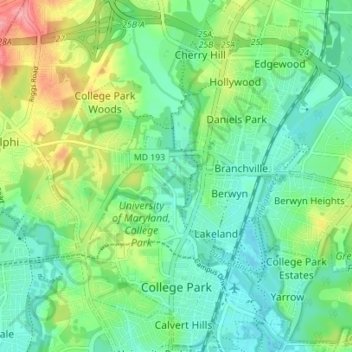
Name: College Park topographic map, elevation, terrain.

Location: College Park, Prince George's County, Maryland, United States (38.97063 -76.96594 39.02487 -76.90893)

Average elevation: 38 m

Minimum elevation: 10 m

Maximum elevation: 100 m

The Lakeland neighborhood was developed beginning in 1890 around the Baltimore and Ohio Railroad, whose Branchville and Calvert Road depots were located approximately one mile to the north and south, respectively. Lakeland was created by Edwin Newman, who improved the original 238 acres (0.96 km2) located to the west of the railroad. He also built a number of the original homes, a small town hall, and a general store. The area was originally envisioned as a resort-type community. However, due to the flood-prone, low-lying topography, the neighborhood became an area of African-American settlement. Around 1900, the Baltimore Gold Fish Company built five artificial lakes in the area to spawn goldfish and rarer species of fish. By 1903 Lakeland was an established African-American community with a school and two churches. Lakeland was central in a group of African American communities located along Route One through Prince Georges County. Lakeland High School opened in 1928 with funding from the Rosenwald Fund, the African American community and the county. Lakeland High served all African American students in the northern half of the county until 1950 when it was converted to a facility for lower grades. The community's first Rosenwald school was a new elementary which opened in 1925.

Wikipedia (CC-BY-SA 3.0)

Other topographic maps

Click on a map to view its topography, its elevation and its terrain.

Hyattsville

United States > Maryland > Prince George's County

Hyattsville, Prince George's County, Maryland, 20781, United States

Average elevation: 61 m

North Brentwood

United States > Maryland > Prince George's County

North Brentwood, Prince George's County, Maryland, United States

Average elevation: 15 m

Cottage City

United States > Maryland > Prince George's County

Cottage City, Prince George's County, Maryland, United States

Average elevation: 17 m

Dinosaur Park

United States > Maryland > Prince George's County > South Laurel > Montpelier Forest

Dinosaur Park, Montpelier Forest, South Laurel, Prince George's County, Maryland, 20708, United States

Average elevation: 67 m

Ammendale

United States > Maryland > Prince George's County > Konterra

Ammendale, Konterra, Prince George's County, Maryland, 20705, United States

Average elevation: 56 m

North Keys

United States > Maryland > Prince George's County

North Keys, Prince George's County, Maryland, United States

Average elevation: 43 m

Landover

United States > Maryland > Prince George's County > Landover

Landover, Prince George's County, Maryland, 20785, United States

Average elevation: 38 m

Queenland

United States > Maryland > Prince George's County > Mellwood

Queenland, Mellwood, Prince George's County, Maryland, 20772, United States

Average elevation: 42 m

Cedarville

United States > Maryland > Prince George's County

Cedarville, Prince George's County, Maryland, United States

Average elevation: 63 m

Westphalia

United States > Maryland > Prince George's County

Westphalia, Prince George's County, Maryland, United States

Average elevation: 62 m

Glassmanor

United States > Maryland > Prince George's County > Glassmanor

Glassmanor, Prince George's County, Maryland, United States

Average elevation: 53 m

Colmar Manor

United States > Maryland > Prince George's County

Colmar Manor, Prince George's County, Maryland, United States

Average elevation: 18 m

Lake Arbor

United States > Maryland > Prince George's County > Lake Arbor

Lake Arbor, Prince George's County, Maryland, United States

Average elevation: 46 m

Hyattsville

United States > Maryland > Prince George's County

Hyattsville, Prince George's County, Maryland, 20782, United States

Average elevation: 24 m

Landover Hills

United States > Maryland > Prince George's County

Landover Hills, Prince George's County, Maryland, United States

Average elevation: 41 m

Capitol Heights

United States > Maryland > Prince George's County

Capitol Heights, Prince George's County, Maryland, United States

Average elevation: 64 m

Fort Washington

United States > Maryland > Prince George's County > Fort Washington

Fort Washington, Prince George's County, Maryland, United States

Average elevation: 29 m

Phelps Corner

United States > Maryland > Prince George's County > Oxon Hill

Phelps Corner, Oxon Hill, Prince George's County, Maryland, 20745, United States

Average elevation: 58 m

Clinton

United States > Maryland > Prince George's County

Clinton, Prince George's County, Maryland, 20735, United States

Average elevation: 64 m

Upper Marlboro

United States > Maryland > Prince George's County

Upper Marlboro, Prince George's County, Maryland, United States

Average elevation: 22 m

Overbrook

United States > Maryland > Prince George's County > Bowie

Overbrook, Bowie, Prince George's County, Maryland, 20715, United States

Average elevation: 32 m

Glenn Dale

United States > Maryland > Prince George's County > Glenn Dale

Glenn Dale, Prince George's County, Maryland, United States

Average elevation: 52 m

District Heights

United States > Maryland > Prince George's County > District Heights

District Heights, Prince George's County, Maryland, 20747, United States

Average elevation: 77 m

Bowie

United States > Maryland > Prince George's County > Bowie

Bowie, Prince George's County, Maryland, United States

Average elevation: 38 m

Adelphi

United States > Maryland > Prince George's County > Adelphi

Adelphi, Prince George's County, Maryland, United States

Average elevation: 56 m

Mount Rainier

United States > Maryland > Prince George's County

Mount Rainier, Prince George's County, Maryland, 20712, United States

Average elevation: 20 m

Laurel

United States > Maryland > Prince George's County

Laurel, Prince George's County, Maryland, 20707, United States

Average elevation: 73 m

Edmonston

United States > Maryland > Prince George's County

Edmonston, Prince George's County, Maryland, 20781, United States

Average elevation: 21 m

Riverdale Park

United States > Maryland > Prince George's County

Riverdale Park, Prince George's County, Maryland, United States

Average elevation: 23 m