
Druid Hill Park topographic map
Interactive map
Click on the map to display elevation.
About this map
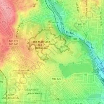
Name: Druid Hill Park topographic map, elevation, terrain.
Average elevation: 78 m
Minimum elevation: 23 m
Maximum elevation: 130 m
Other topographic maps
Click on a map to view its topography, its elevation and its terrain.
Baltimore
United States > Maryland > Baltimore
Baltimore, Maryland, 21203, United States
Average elevation: 65 m
Inner Harbor
United States > Maryland > Baltimore
Inner Harbor, Baltimore, Maryland, United States
Average elevation: 11 m
Middle East
United States > Maryland > Baltimore
Middle East, Baltimore, Maryland, United States
Average elevation: 29 m
Broadway East
United States > Maryland > Baltimore
Broadway East, Baltimore, Maryland, United States
Average elevation: 36 m