
Make a donation
Gear up for your next adventure:
As an Amazon Associate, this site earns from qualifying purchases at no extra cost to you.
Fairland topographic map
Click on the map to display elevation.
Make a donation
Gear up for your next adventure:
As an Amazon Associate, this site earns from qualifying purchases at no extra cost to you.
About this map
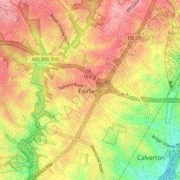
Name: Fairland topographic map, elevation, terrain.
Location: Fairland, Montgomery County, Maryland, United States (39.05127 -76.98117 39.10146 -76.92385)
Average elevation: 111 m
Minimum elevation: 50 m
Maximum elevation: 152 m
Make a donation
Gear up for your next adventure:
As an Amazon Associate, this site earns from qualifying purchases at no extra cost to you.
Other topographic maps
Click on a map to view its topography, its elevation and its terrain.
Sandy Spring Meadow
United States > Maryland > Montgomery County > Sandy Spring
Average elevation: 136 m
Make a donation
Gear up for your next adventure:
As an Amazon Associate, this site earns from qualifying purchases at no extra cost to you.
Burnt Mills Village
United States > Maryland > Montgomery County > Burnt Mills
Average elevation: 104 m
Lock 22: Pennyfield Lock
United States > Maryland > Montgomery County > Travilah
Ground was broken for construction of the C&O Canal on July 4, 1828. One of the early plans was for the canal to be a way to connect the Chesapeake Bay with the Ohio River. The canal has several types of locks, including 74 lift locks necessary to handle a 608-foot (185 m) difference in elevation between the…
Average elevation: 73 m
Make a donation
Gear up for your next adventure:
As an Amazon Associate, this site earns from qualifying purchases at no extra cost to you.
Seneca Park
United States > Maryland > Montgomery County > Montgomery Village
Average elevation: 124 m