
Make a donation
Gear up for your next adventure:
As an Amazon Associate, this site earns from qualifying purchases at no extra cost to you.
Mason Island topographic map
Click on the map to display elevation.
Make a donation
Gear up for your next adventure:
As an Amazon Associate, this site earns from qualifying purchases at no extra cost to you.
About this map
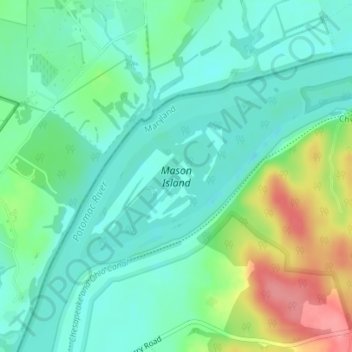
Name: Mason Island topographic map, elevation, terrain.
Location: Mason Island, Montgomery County, Maryland, United States (39.16935 -77.51496 39.18294 -77.49245)
Average elevation: 78 m
Minimum elevation: 53 m
Maximum elevation: 136 m
Make a donation
Gear up for your next adventure:
As an Amazon Associate, this site earns from qualifying purchases at no extra cost to you.
Other topographic maps
Click on a map to view its topography, its elevation and its terrain.
North Potomac
United States > Maryland > Montgomery County > North Potomac
Between the 1990 and 2000 census, North Potomac gained and lost land. The loss was caused when a portion of the North Potomac territory, plus Potomac territory, was used to create the Travilah census designated place. According to the United States Census Bureau, North Potomac has a total area of 6.6 square…
Average elevation: 116 m
Sandy Spring Meadow
United States > Maryland > Montgomery County > Sandy Spring
Average elevation: 136 m
Make a donation
Gear up for your next adventure:
As an Amazon Associate, this site earns from qualifying purchases at no extra cost to you.
Make a donation
Gear up for your next adventure:
As an Amazon Associate, this site earns from qualifying purchases at no extra cost to you.
Burnt Mills Village
United States > Maryland > Montgomery County > Burnt Mills
Average elevation: 104 m
Make a donation
Gear up for your next adventure:
As an Amazon Associate, this site earns from qualifying purchases at no extra cost to you.
Seneca Park
United States > Maryland > Montgomery County > Montgomery Village
Average elevation: 124 m