
Sahibganj topographic map
Interactive map
Click on the map to display elevation.
About this map
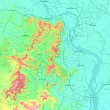
Name: Sahibganj topographic map, elevation, terrain.
Location: Sahibganj, Jharkhand, Inde (24.71373 87.44904 25.34840 87.97355)
Average elevation: 77 m
Minimum elevation: 14 m
Maximum elevation: 458 m
Other topographic maps
Click on a map to view its topography, its elevation and its terrain.
Rāmnagartola
Rāmnagartola, Pakaur, Pakur District, Jharkhand, 816107, Inde
Average elevation: 34 m
Sahibganj (block)
Sahibganj (block), Sahibganj District, Jharkhand, 816109, Inde
Average elevation: 60 m