
Latehar topographic map
Interactive map
Click on the map to display elevation.
About this map
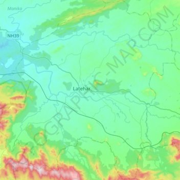
Name: Latehar topographic map, elevation, terrain.
Location: Latehar, Latehar District, Jharkhand, 829206, Inde (23.61506 84.37225 23.86932 84.64524)
Average elevation: 452 m
Minimum elevation: 325 m
Maximum elevation: 1,015 m
Other topographic maps
Click on a map to view its topography, its elevation and its terrain.
Rāmnagartola
Rāmnagartola, Pakaur, Pakur District, Jharkhand, 816107, Inde
Average elevation: 34 m
Sahibganj (block)
Sahibganj (block), Sahibganj District, Jharkhand, 816109, Inde
Average elevation: 60 m