
Gumla topographic map
Interactive map
Click on the map to display elevation.
About this map
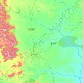
Name: Gumla topographic map, elevation, terrain.
Location: Gumla, Jharkhand, Inde (22.95492 84.41028 23.22995 84.75223)
Average elevation: 647 m
Minimum elevation: 520 m
Maximum elevation: 1,013 m
Other topographic maps
Click on a map to view its topography, its elevation and its terrain.
Rāmnagartola
Rāmnagartola, Pakaur, Pakur District, Jharkhand, 816107, Inde
Average elevation: 34 m
Sahibganj (block)
Sahibganj (block), Sahibganj District, Jharkhand, 816109, Inde
Average elevation: 60 m