
Thank you for supporting this site ❤️
Make a donation
Make a donation
Gear up for your next adventure:
As an Amazon Associate, this site earns from qualifying purchases at no extra cost to you.
Kasba topographic map
Click on the map to display elevation.
Thank you for supporting this site ❤️
Make a donation
Make a donation
Gear up for your next adventure:
As an Amazon Associate, this site earns from qualifying purchases at no extra cost to you.
About this map
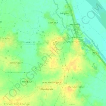
Name: Kasba topographic map, elevation, terrain.
Location: Kasba, Rajmahal, Sahibganj District, Jharkhand, Inde (25.06075 87.74601 25.08040 87.78961)
Average elevation: 31 m
Minimum elevation: 18 m
Maximum elevation: 45 m
Thank you for supporting this site ❤️
Make a donation
Make a donation
Gear up for your next adventure:
As an Amazon Associate, this site earns from qualifying purchases at no extra cost to you.