Geolocate

Albesa topographic map

Click on the map to display elevation.

About this map

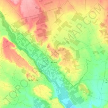
Name: Albesa topographic map, elevation, terrain.

Location: Albesa, Noguera, Lérida, Cataluña, 25135, España (41.71926 0.61492 41.79462 0.71221)

Average elevation: 248 m

Minimum elevation: 195 m

Maximum elevation: 306 m

Other topographic maps

Click on a map to view its topography, its elevation and its terrain.

Colldelrat

España > Cataluña > Noguera > Artesa de Segre

Average elevation: 425 m

Coll de Comiols

España > Cataluña > Noguera > Artesa de Segre

Average elevation: 1,029 m

Pedrissa

España > Cataluña > Noguera > Camarasa

Average elevation: 292 m

Folquer

España > Cataluña > Noguera > Artesa de Segre

Average elevation: 741 m

Montargull

España > Cataluña > Noguera > Artesa de Segre

Average elevation: 508 m

Coll del Portell

España > Cataluña > Noguera > Balaguer

Average elevation: 260 m

Vernet

España > Cataluña > Noguera > Artesa de Segre

Average elevation: 347 m

Montgai

España > Cataluña > Noguera > Montgai > Montgai

Average elevation: 308 m

Foradada

España > Cataluña > Noguera > Foradada > Foradada

Average elevation: 402 m

Gear up for your next adventure:

🥾Approach Boots - Comfortable boots for hiking and climbing approaches
🥾Mountain Hiking Shoes - Shoes with superior grip for mountainous terrain
Lightweight Backpacking Tent - Compact tent for efficient hiking trips
🧦Hiking Liner Socks - Thin base layer to prevent friction and blisters
🛏️Sleeping Bag - Warm and compact sleeping bags for outdoor camping

As an Amazon Associate, this site earns from qualifying purchases at no extra cost to you.