Geolocate

Colldelrat topographic map

Click on the map to display elevation.

About this map

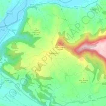
Name: Colldelrat topographic map, elevation, terrain.

Location: Colldelrat, Artesa de Segre, Noguera, Cataluña, 25739, España (41.87950 1.07256 41.91950 1.11256)

Average elevation: 425 m

Minimum elevation: 307 m

Maximum elevation: 661 m

Gear up for your next adventure:

🛶Canoe Life Vest - Safety vest for water sports
🧭Orienteering Kit - Tools for map reading and navigation in the wild
🥾Hiking Leggings - Comfortable leggings for outdoor activities
🧦Crew Hiking Socks - Comfortable socks for long-distance hikes
🥾Light Trekking Boots - Supportive boots for multi-day treks

As an Amazon Associate, this site earns from qualifying purchases at no extra cost to you.