Geolocate

Montgai topographic map

Click on the map to display elevation.

About this map

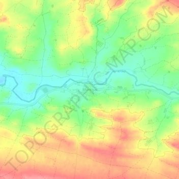
Name: Montgai topographic map, elevation, terrain.

Location: Montgai, Noguera, Lérida, Cataluña, 25315, España (41.78000 0.94143 41.82000 0.98143)

Average elevation: 308 m

Minimum elevation: 267 m

Maximum elevation: 351 m

Gear up for your next adventure:

🧥Softshell Hiking Jacket - The perfect balance of wind protection and breathability
🥾Approach Shoes - Shoes designed for climbing approaches and rugged trails
🔦LED Headtorch - Bright and durable light for night activities
🏃Hydration Running Vest - Carry water and maps close to your body for speed
🔪Outdoor Multitool - Versatile tool for repairs and food prep in the wild

As an Amazon Associate, this site earns from qualifying purchases at no extra cost to you.