
Valladolid topographic map
Interactive map
Click on the map to display elevation.
About this map
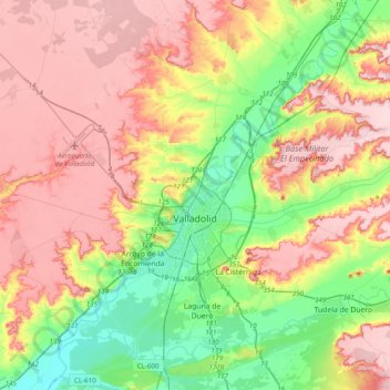
Name: Valladolid topographic map, elevation, terrain.
Location: Valladolid, Castile and León, Spain (41.52333 -4.92818 41.81551 -4.63087)
Average elevation: 768 m
Minimum elevation: 671 m
Maximum elevation: 868 m
Valladolid is located at roughly 735 metres above sea level, at the centre of the Meseta Norte, the plateau drained by the Duero river basin covering a major part of the Northwest of the Iberian Peninsula. The primitive urban core was built ex novo in the 11th century on a small elevation near the confluence of the Esgueva with the Pisuerga, on the left-bank of the later river. The city of Valladolid currently lies on both banks of the Pisuerga, a major right-bank tributary of the Douro.
Other topographic maps
Click on a map to view its topography, its elevation and its terrain.
San Cristóbal de Segovia
San Cristóbal de Segovia, Segovia, Castile and León, 40197, Spain
Average elevation: 1,060 m
Presa Vieja de Las Navas del Marques
Spain > Castile and León > Peguerinos
Presa Vieja de Las Navas del Marques, Peguerinos, Ávila, Castile and León, Spain
Average elevation: 1,496 m
Toroño
Spain > Castile and León > Porto
Toroño, Porto, Zamora, Castile and León, Spain
Average elevation: 1,495 m
Peñafiel
Peñafiel, Valladolid, Castile and León, 47300, Spain
Average elevation: 824 m
Río de la Mora
Spain > Castile and León > Navalacruz
Río de la Mora, Navalacruz, Ávila, Castile and León, Spain
Average elevation: 1,495 m
Milagros
Milagros, Burgos, Castile and León, 09460, Spain
Average elevation: 884 m
Mijares
Mijares, Ávila, Castile and León, 05461, Spain
Average elevation: 932 m
Sorriba del Esla
Spain > Castile and León > Cistierna
Sorriba del Esla, Cistierna, León, Castile and León, 24800, Spain
Average elevation: 1,021 m
Valdelugueros
Valdelugueros, León, Castile and León, 24845, Spain
Average elevation: 1,521 m
Sahechores de Rueda
Sahechores de Rueda, Cubillas de Rueda, León, Castile and León, Spain
Average elevation: 885 m
El Burgo Ranero
El Burgo Ranero, León, Castile and León, 24343, Spain
Average elevation: 878 m
Villamanín
Villamanín, León, Castile and León, Spain
Average elevation: 1,440 m
Cubillas de Rueda
Cubillas de Rueda, León, Castile and León, Spain
Average elevation: 972 m
Castroañe
Spain > Castile and León > Villaselán
Castroañe, Villaselán, León, Castile and León, 24344, Spain
Average elevation: 873 m
Villarmayor
Villarmayor, Salamanca, Castile and León, Spain
Average elevation: 804 m
Castillo de Alba
Spain > Castile and León > Losacino
Castillo de Alba, Losacino, Zamora, Castile and León, Spain
Average elevation: 745 m
Camino de Santiago
Spain > Castile and León > Zazuar
Camino de Santiago, Zazuar, Burgos, Castile and León, 09490, Spain
Average elevation: 848 m
Rágama
Spain > Castile and León > Rágama
Rágama, Salamanca, Castile and León, Spain
Average elevation: 845 m
Lanuza
Spain > Castile and León > Fresneda de la Sierra Tirón
Lanuza, Fresneda de la Sierra Tirón, Burgos, Castile and León, 26288, Spain
Average elevation: 1,215 m
El Arenal
Spain > Castile and León > Ávila > El Arenal
El Arenal, Ávila, Castile and León, Spain
Average elevation: 1,301 m
Membribe de la Sierra
Spain > Castile and León > Membribe de la Sierra
Membribe de la Sierra, Salamanca, Castile and León, Spain
Average elevation: 995 m
Osorno la Mayor
Spain > Castile and León > Osorno la Mayor
Osorno la Mayor, Palencia, Castile and León, 34460, Spain
Average elevation: 820 m
Los Altos
Los Altos, Burgos, Castile and León, 09551, Spain
Average elevation: 920 m
San Justo
Spain > Castile and León > San Justo
San Justo, Galende, Castile and León, Spain
Average elevation: 1,332 m
La Tala
Spain > Castile and León > La Tala
La Tala, Guijuelo, Castile and León, Spain
Average elevation: 946 m
Buenavista
Buenavista, Salamanca, Castile and León, Spain
Average elevation: 936 m
Manzanillo
Spain > Castile and León > Manzanillo
Manzanillo, Quintanilla de Onésimo, Castile and León, Spain
Average elevation: 825 m
Martínez
Spain > Castile and León > Martínez
Martínez, Valle Amblés y Sierra de Ávila, Ávila, Castile and León, Spain
Average elevation: 1,110 m
La Maya
Spain > Castile and León > La Maya
La Maya, Tierra de Alba, Salamanca, Castile and León, Spain
Average elevation: 850 m
Tejeda
Spain > Castile and León > Tejeda
Tejeda, Campo de Salamanca, Salamanca, Castile and León, 37607, Spain
Average elevation: 941 m
Valdorros
Spain > Castile and León > Valdorros
Valdorros, Arlanza, Burgos, Castile and León, 09320, Spain
Average elevation: 914 m
Aranda de Duero
Aranda de Duero, Burgos, Castile and León, Spain
Average elevation: 846 m
Contreras
Spain > Castile and León > Contreras
Contreras, Sierra de la Demanda, Burgos, Castile and León, Spain
Average elevation: 1,089 m
Santo Tomé del Puerto
Santo Tomé del Puerto, Segovia, Castile and León, 40590, Spain
Average elevation: 1,347 m