
Make a donation
Gear up for your next adventure:
As an Amazon Associate, this site earns from qualifying purchases at no extra cost to you.
Lookout Point topographic map
Click on the map to display elevation.
Make a donation
Gear up for your next adventure:
As an Amazon Associate, this site earns from qualifying purchases at no extra cost to you.
About this map
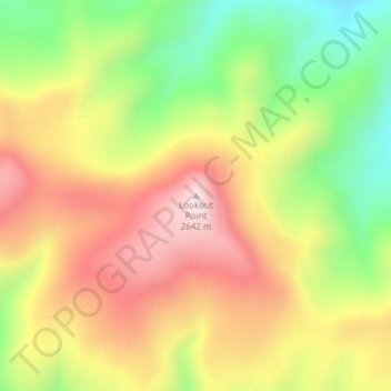
Name: Lookout Point topographic map, elevation, terrain.
Location: Lookout Point, Clark County, Idaho, United States (44.43736 -112.04781 44.43746 -112.04771)
Average elevation: 2,400 m
Minimum elevation: 2,136 m
Maximum elevation: 2,649 m
Make a donation
Gear up for your next adventure:
As an Amazon Associate, this site earns from qualifying purchases at no extra cost to you.
Other topographic maps
Click on a map to view its topography, its elevation and its terrain.
Lake Coeur d'Alene
United States > Idaho > Kootenai County > Harrison
The lake's elevation varies from 2,128 feet (649 m) above sea level in the summer to up to 7 feet (2.1 m) lower in the winter, controlled by the Post Falls Dam 9 miles (14 km) below the lake on the Spokane River.
Average elevation: 827 m
Kooskia
United States > Idaho > Idaho County
Kooskia is located at 46°8′30″N 115°58′47″W / 46.14167°N 115.97972°W / 46.14167; -115.97972 (46.139, -115.979), at an elevation of 1,293 feet (394 m) [above sea level.
Average elevation: 459 m
Clayton
United States > Idaho > Custer County
Clayton is located at 44°15′32″N 114°23′59″W / 44.25889°N 114.39972°W / 44.25889; -114.39972 (44.259014, -114.399725), at an elevation of 5,489 feet (1,673 m) above sea level.
Average elevation: 1,965 m
Emmett
United States > Idaho > Gem County
According to the United States Census Bureau, the city has a total area of 2.82 square miles (7.30 km2), of which 2.80 square miles (7.25 km2) is land and 0.02 square miles (0.05 km2) is water. It is located south of the Payette River, at an elevation of 2,362 feet (720 m) above sea level.
Average elevation: 738 m
Make a donation
Gear up for your next adventure:
As an Amazon Associate, this site earns from qualifying purchases at no extra cost to you.
Make a donation
Gear up for your next adventure:
As an Amazon Associate, this site earns from qualifying purchases at no extra cost to you.
Idaho Panhandle National Forests
Elevations on the IPNF range from 2,100 to 7,600 feet with as much as 80 inches of precipitation at high elevations. The IPNF is characterized by several mountain ranges including the Selkirk Mountains, Cabinet Mountains, Purcell Mountains, Coeur d'Alene Mountains, and Bitterroot Range, interspersed with large…
Average elevation: 1,122 m
Cambridge
United States > Idaho > Washington County
Cambridge is located at 44°34′18″N 116°40′41″W / 44.57167°N 116.67806°W / 44.57167; -116.67806 (44.571535, −116.678013), at an elevation of 2,661 feet (811 m) above sea level. According to the United States Census Bureau, the city has a total area of 0.49 square miles (1.27 km2), of…
Average elevation: 811 m
Make a donation
Gear up for your next adventure:
As an Amazon Associate, this site earns from qualifying purchases at no extra cost to you.
Winchester
United States > Idaho > Lewis County
Winchester is located at 46°14′27″N 116°37′24″W / 46.24083°N 116.62333°W / 46.24083; -116.62333 , at an elevation of 3,980 feet (1,210 m) above sea level.
Average elevation: 1,214 m
Make a donation
Gear up for your next adventure:
As an Amazon Associate, this site earns from qualifying purchases at no extra cost to you.
Make a donation
Gear up for your next adventure:
As an Amazon Associate, this site earns from qualifying purchases at no extra cost to you.
Fairfield
United States > Idaho > Camas County
Fairfield is located at City 43°20′46″N 114°47′28″W / 43.34611°N 114.79111°W / 43.34611; -114.79111 (43.346000, -114.791159), at an elevation of 5,066 feet (1,544 m) above sea level.
Average elevation: 1,546 m
American Falls
United States > Idaho > Power County
American Falls is located at 42°46′52″N 112°51′20″W / 42.78111°N 112.85556°W / 42.78111; -112.85556 (42.781121, -112.855694), at an elevation of 4,406 feet (1,343 m).
Average elevation: 1,346 m
Make a donation
Gear up for your next adventure:
As an Amazon Associate, this site earns from qualifying purchases at no extra cost to you.
Aberdeen
United States > Idaho > Bingham County
Aberdeen is located at 42°56′36″N 112°50′22″W / 42.94333°N 112.83944°W / 42.94333; -112.83944 (42.943405, -112.839322), at an elevation of 4,403 feet (1,342 m) above sea level. According to the United States Census Bureau, the city has a total area of 1.03 square miles (2.67 km2), all of it land.
Average elevation: 1,341 m
Make a donation
Gear up for your next adventure:
As an Amazon Associate, this site earns from qualifying purchases at no extra cost to you.
Ferdinand
United States > Idaho > Idaho County
Ferdinand is located at 46°9′10″N 116°23′26″W / 46.15278°N 116.39056°W / 46.15278; -116.39056 (46.152701, -116.390438), at an elevation of 3,720 feet (1,130 m) above sea level on the Camas Prairie.
Average elevation: 1,148 m
Make a donation
Gear up for your next adventure:
As an Amazon Associate, this site earns from qualifying purchases at no extra cost to you.
Make a donation
Gear up for your next adventure:
As an Amazon Associate, this site earns from qualifying purchases at no extra cost to you.
Reubens
United States > Idaho > Lewis County
Reubens is located at 46°19′25″N 116°32′31″W / 46.32361°N 116.54194°W / 46.32361; -116.54194, at an elevation of 3,527 feet (1,075 m) above sea level.
Average elevation: 1,077 m
Make a donation
Gear up for your next adventure:
As an Amazon Associate, this site earns from qualifying purchases at no extra cost to you.
Tensed
United States > Idaho > Benewah County
Tensed is located at 47°9′37″N 116°55′27″W / 47.16028°N 116.92417°W / 47.16028; -116.92417 (47.160284, -116.924304), at an elevation of 2,562 feet (781 m) above sea level.
Average elevation: 785 m
Make a donation
Gear up for your next adventure:
As an Amazon Associate, this site earns from qualifying purchases at no extra cost to you.
Onaway
United States > Idaho > Latah County
Onaway is located at 46°55′43″N 116°53′21″W / 46.92861°N 116.88917°W / 46.92861; -116.88917 (46.928565, -116.889074), at an elevation of 2,621 feet (799 m) above sea level. According to the United States Census Bureau, the city has a total area of 0.15 square miles (0.39 km2), all of it land.
Average elevation: 794 m
Oldtown
United States > Idaho > Bonner County
Oldtown is located at 48°11′8″N 117°1′49″W / 48.18556°N 117.03028°W / 48.18556; -117.03028 (48.185623, -117.030158), at an elevation of 2,134 feet (650 meters).
Average elevation: 682 m
Make a donation
Gear up for your next adventure:
As an Amazon Associate, this site earns from qualifying purchases at no extra cost to you.
Make a donation
Gear up for your next adventure:
As an Amazon Associate, this site earns from qualifying purchases at no extra cost to you.
Bancroft
United States > Idaho > Caribou County
Bancroft is located at 42°43′10″N 111°53′10″W / 42.71944°N 111.88611°W / 42.71944; -111.88611 (42.719440, -111.886194), at an elevation of 5,420 feet (1,650 m).
Average elevation: 1,658 m
Declo
United States > Idaho > Cassia County
Declo is located at 42°31′10″N 113°37′48″W / 42.51944°N 113.63000°W / 42.51944; -113.63000 (42.519441, -113.629978), at an elevation of 4,219 feet (1,286 m) above sea level. According to the United States Census Bureau, the city has a total area of 0.28 square miles (0.73 km2), all of it land.
Average elevation: 1,284 m
Make a donation
Gear up for your next adventure:
As an Amazon Associate, this site earns from qualifying purchases at no extra cost to you.
Newdale
United States > Idaho > Fremont County
Newdale is the nearest city to the Teton Dam, which failed on June 5, 1976. Newdale did not receive any flooding or damage, due to its elevation and position relative to the dam.
Average elevation: 1,550 m
Clifton
United States > Idaho > Franklin County
Clifton is located at 42°11′15″N 112°0′21″W / 42.18750°N 112.00583°W / 42.18750; -112.00583 (42.187585, -112.005856), at 4,860 feet (1,480 m) in elevation.
Average elevation: 1,494 m
Make a donation
Gear up for your next adventure:
As an Amazon Associate, this site earns from qualifying purchases at no extra cost to you.
Make a donation
Gear up for your next adventure:
As an Amazon Associate, this site earns from qualifying purchases at no extra cost to you.
Make a donation
Gear up for your next adventure:
As an Amazon Associate, this site earns from qualifying purchases at no extra cost to you.
Smelterville
United States > Idaho > Shoshone County
Smelterville is located at 47°32′34″N 116°10′45″W / 47.54278°N 116.17917°W / 47.54278; -116.17917 (47.542690, -116.179281), at an elevation of 2,234 feet (681 m) above sea level.
Average elevation: 742 m
Make a donation
Gear up for your next adventure:
As an Amazon Associate, this site earns from qualifying purchases at no extra cost to you.
Arco
United States > Idaho > Butte County
Arco Peak, located two mile north of the community at an elevation of 7547 feet, rises 2220 feet above the city.
Average elevation: 1,634 m
Genesee
United States > Idaho > Latah County
Genesee is located at 46°33.0′N 116°55.5′W / 46.5500°N 116.9250°W / 46.5500; -116.9250 (46.5506, -116.9245)., at an elevation of 2,680 feet (817 m) above sea level. Located in the Palouse region, it is approximately 14 miles (23 km) south of Moscow, about halfway to Lewiston. The city center…
Average elevation: 824 m
Make a donation
Gear up for your next adventure:
As an Amazon Associate, this site earns from qualifying purchases at no extra cost to you.
Sugar City
United States > Idaho > Madison County
Sugar City is located in northern Madison County at 43°52′20″N 111°44′50″W / 43.87222°N 111.74722°W / 43.87222; -111.74722 (43.872317, -111.747331), at an elevation of 4,895 feet (1,492 m) above sea level. U.S. Route 20 runs along the western edge of the city, leading southwest 5 miles (8…
Average elevation: 1,494 m
Make a donation
Gear up for your next adventure:
As an Amazon Associate, this site earns from qualifying purchases at no extra cost to you.
Make a donation
Gear up for your next adventure:
As an Amazon Associate, this site earns from qualifying purchases at no extra cost to you.
Hayden
United States > Idaho > Kootenai County
According to the United States Census Bureau, the city has a total area of 9.61 square miles (24.89 km2), of which 9.60 square miles (24.86 km2) is land and 0.01 square miles (0.03 km2) is water. It lies at the southwestern end of Hayden Lake, and the elevation of the city is 2,287 feet (697 m) above sea level.
Average elevation: 709 m
Lava Hot Springs
United States > Idaho > Bannock County
Lava Hot Springs is located at 42°37′10″N 112°0′51″W / 42.61944°N 112.01417°W / 42.61944; -112.01417 (42.619482, -112.014283), at an elevation of 5,020 feet (1,530 m) above sea level.
Average elevation: 1,611 m
Make a donation
Gear up for your next adventure:
As an Amazon Associate, this site earns from qualifying purchases at no extra cost to you.
Kamiah
United States > Idaho > Lewis County
The city is located at the confluence of Lawyer Creek and the Clearwater River on the left bank of the latter. In the Kamiah area, the Lewis-Idaho County line follows Lawyer Creek to its confluence with the Clearwater, and then turns to follow the Clearwater. U.S. Route 12 passes through Kamiah, crossing from…
Average elevation: 399 m
Snake River
United States > Idaho > Washington County
Mountain ranges in the Snake watershed include the Teton Range, Bitterroot Range, Clearwater Mountains, Seven Devils Mountains, and the extreme northwestern end of the Wind River Range. Grand Teton is the highest point in the Snake River watershed, reaching 13,775 feet (4,199 m) in elevation. The elevation of…
Average elevation: 643 m
St. Charles
United States > Idaho > Bear Lake County
St. Charles is located at 42°6′45″N 111°23′24″W / 42.11250°N 111.39000°W / 42.11250; -111.39000 (42.112493, -111.390001), at an elevation of 5,965 feet (1,818 m) above sea level.
Average elevation: 1,830 m
Make a donation
Gear up for your next adventure:
As an Amazon Associate, this site earns from qualifying purchases at no extra cost to you.
Glenns Ferry
United States > Idaho > Elmore County
Glenns Ferry is located at 42°57′7″N 115°18′4″W / 42.95194°N 115.30111°W / 42.95194; -115.30111 (42.951954, -115.301132), at an elevation of 2,569 feet (783 m) above sea level.
Average elevation: 798 m
Make a donation
Gear up for your next adventure:
As an Amazon Associate, this site earns from qualifying purchases at no extra cost to you.
New Meadows
United States > Idaho > Adams County
New Meadows is located at 44°58′13″N 116°17′7″W / 44.97028°N 116.28528°W / 44.97028; -116.28528 (44.970405, -116.285283), at an elevation of 3,868 feet (1,179 m) above sea level.
Average elevation: 1,184 m
Buhl
United States > Idaho > Twin Falls County
Buhl is located at 42°36′0″N 114°45′43″W / 42.60000°N 114.76194°W / 42.60000; -114.76194 (42.600102, -114.761867), at an elevation of 3,770 feet (1,149 m) above sea level.
Average elevation: 1,149 m
Make a donation
Gear up for your next adventure:
As an Amazon Associate, this site earns from qualifying purchases at no extra cost to you.