
Make a donation
Gear up for your next adventure:
As an Amazon Associate, this site earns from qualifying purchases at no extra cost to you.
St. Charles topographic map
Click on the map to display elevation.
Make a donation
Gear up for your next adventure:
As an Amazon Associate, this site earns from qualifying purchases at no extra cost to you.
St. Charles
St. Charles is located at 42°6′45″N 111°23′24″W / 42.11250°N 111.39000°W / 42.11250; -111.39000 (42.112493, -111.390001), at an elevation of 5,965 feet (1,818 m) above sea level.
Make a donation
Gear up for your next adventure:
As an Amazon Associate, this site earns from qualifying purchases at no extra cost to you.
About this map
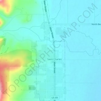
Name: St. Charles topographic map, elevation, terrain.
Location: St. Charles, Bear Lake County, Idaho, 83272, United States (42.10237 -111.39642 42.12994 -111.38495)
Average elevation: 1,830 m
Minimum elevation: 1,805 m
Maximum elevation: 1,948 m
Make a donation
Gear up for your next adventure:
As an Amazon Associate, this site earns from qualifying purchases at no extra cost to you.
Other topographic maps
Click on a map to view its topography, its elevation and its terrain.